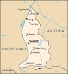
Geography of Liechtenstein
The principality of Liechtenstein encompasses most of the eastern half of the Rhine Valley, wedged between Austria and Switzerland.
The majority of the country's population is found in the western half along the Rhine River.
[1] Along with Uzbekistan, Liechtenstein is one of only two doubly landlocked countries in the world.
Geographic coordinates: 47°10′N 9°32′E / 47.167°N 9.533°E / 47.167; 9.533 (Liechtenstein) Area: 160 km2 (land, 0 km2 water) Land boundaries Lake Land use Terrain Natural resources: Extreme points: Continental; cold, cloudy winters with frequent snow or rain; cool to moderately warm, cloudy, humid summers, great variety of microclimates based on elevation.
Party to: Air Pollution, Air Pollution-Persistent Organic Pollutants, Air Pollution-Nitrogen Oxides, Air Pollution-Sulphur 85, Air Pollution-Sulphur 94, Air Pollution-Volatile Organic Compounds, Biodiversity, Climate Change, Climate Change-Kyoto Protocol, Desertification, Endangered Species, Hazardous Wastes, Ozone Layer Protection, Wetlands, Signed, but not ratified: Law of the Sea This article incorporates public domain material from The World Factbook.