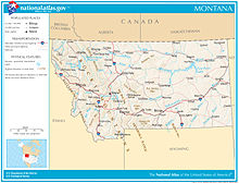
Geography of Montana
[19] The Beartooth Plateau is the largest continuous land mass over 10,000 feet (3,000 m) high in the continental United States.
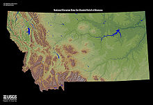
East and north of this transition zone are the expansive and sparsely populated Northern Plains, with tableland prairies, smaller island mountain ranges, and badlands.
[5] Many of these isolated eastern ranges were created about 120 to 66 million years ago when magma welling up from the interior cracked and bowed the earth's surface here.
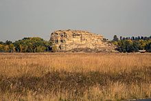
[34] The area east of the divide in the state's north-central portion is known for the Missouri Breaks and other significant rock formations.
[37] Surface soils in the area are highly diverse, and greatly affected by the local geology, whether glaciated plain, intermountain basin, mountain foothills, or tableland.
[38] Foothill regions are often covered in weathered stone or broken slate, or consist of uncovered bare rock (usually igneous, quartzite, sandstone, or shale).
[39] The soil of intermountain basins usually consists of clay, gravel, sand, silt, and volcanic ash, much of it laid down by lakes which covered the region during the Oligocene 33 to 23 million years ago.
[44] Paleontologist Jack Horner of the Museum of the Rockies in Bozeman brought this formation to the world's attention with several major finds.
[45] Montana has thousands of named rivers and creeks,[46] 450 miles (720 km) of which are known for "blue-ribbon" trout fishing.
Montana is one of few geographic areas in the world whose rivers form parts of three major watersheds (i.e. where two continental divides intersect).
[57] From this point, it then flows generally east through fairly flat agricultural land and the Missouri Breaks to Fort Peck reservoir.
[58] The Missouri enters North Dakota near Fort Union,[59] having drained more than half the land area of Montana (82,000 square miles (210,000 km2)).
[57] Nearly one-third of the Missouri River in Montana lies behind 10 dams: Toston, Canyon Ferry, Hauser, Holter, Black Eagle, Rainbow, Cochrane, Ryan, Morony, and Fort Peck.
[60] Other major Montana tributaries of the Missouri include the Smith,[61] Milk,[62] Marias,[63] Judith,[64] and Musselshell Rivers.
[68] It flows north through Yellowstone National Park, enters Montana near Gardiner, and passes through the Paradise Valley to Livingston.
[71] It is the longest undammed, free-flowing river in the contiguous United States,[72][73] and drains about a quarter of Montana (36,000 square miles (93,000 km2)).
[57] Major tributaries of the Yellowstone include the Boulder,[74] Stillwater,[75] Clarks Fork,[76] Bighorn,[77] Tongue,[78] and Powder Rivers.
Flowers native to Montana include asters, bitterroots, daisies, lupins, poppies, primroses, columbine, lilies, orchids, and dryads.
Montana is home to diverse fauna including 14 amphibian,[82] 90 fish,[83] 117 mammal,[84] 20 reptile,[85] and 427 bird[86] species.
The CSKT Bison Range is managed by the Confederated Salish and Kootenai Tribes and the American Prairie is owned and operated by a non-profit organization.
The U.S. Department of the Interior Bureau of Reclamation administers approximately 300,000 acres (1,200 km2) of land and water surface in the state.
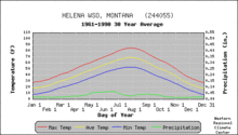
[92] Areas managed by the National Park Service include:[93] Montana is a large state with considerable variation in geography, topography and elevation, and the climate is equally varied.
The area west of the divide has a modified northern Pacific Coast climate, with milder winters, cooler summers, less wind, and a longer growing season.
[94] Snowfall has been recorded in all months of the year in the more mountainous areas of central and western Montana, though it is rare in July and August.
These steady 25–50 mph (40–80 km/h) (or more) winds can suddenly warm parts of Montana, especially areas just to the east of the mountains, where temperatures sometimes rise up to 50–60 °F (10.0–15.6 °C) for 10 days or longer.
[98] Miles City recorded the highest mean sea level pressure in the United States on December 24, 1983.
The mountain ranges block the moist Pacific air, holding moisture in the western valleys, and creating rain shadows to the east.
[105] The combination of warmer weather, attack by beetles, and mismanagement has led to a substantial increase in the severity of forest fires in Montana.
The state also has five Micropolitan Statistical Areas, centered on Bozeman, Butte, Helena, Kalispell and Havre.
[118] Collectively all of these areas (excluding Havre) are known informally as the "big seven", as they are consistently the seven largest communities in the state (their rank order in terms of population is Billings, Missoula, Great Falls, Bozeman, Butte, Helena and Kalispell, according to the 2010 U.S.