Geography of Alberta
Alberta's landscape is marked by the impact of the Wisconsin Glaciation, about 75,000 to 11,000 years ago, when the entire future province was covered in ice.
As the ice sheet receded, the landscape was changed, and large amounts of glacial till were left behind.
From the southern boundary line for 2.5° north the prairie is dry, but of good soil, which grows excellent crops when irrigated.
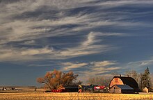
The appearance of the prairie section of the province is that of undulating grasslands, with rounded sloping ridges covered with shorter grasses, which serve for the support of large herds of beef cattle.
The wooded portions of the terrain are dotted with clumps and belts of trees of moderate size, giving them a park-like appearance.
In 1986, Agriculture Canada published a map listing the following physiographic regions to be present at least partially within Alberta:[3] From a distance of about 100 km (62 mi) the mountains are constantly in view in clear weather.
The Canadian Rockies are ascended by a gradual approach from the east, but are exceedingly abrupt on their transalpine slope in British Columbia.
While a number of fresh water, or in some cases brackish, lakes each less than 260 km2 (100 sq mi) in extent are situated in Alberta, two of more considerable size are found.
The contrast between warming, dry winds descending from the Rockies and proximate cold air in Yukon, however, gives Alberta (and the adjacent Mackenzie Basin) during the winter the highest variability in monthly temperatures anywhere in the world.
[4] Exceptionally warm winter months in the province can be as warm as oceanic climates at similar latitudes – for instance Edmonton averaged 1.1 °C (34.0 °F) in February 1977 – whereas the coldest winter months like January 1950 when Edmonton averaged −27.8 °C (−18.0 °F) are comparably cold to such Siberian localities as Aldan, Sakha.
Most of Southern Alberta east of the Rockies and outside of the Cypress Hills, especially Palliser's Triangle, is a dry steppe, with most locations having an annual average precipitation of 280-430mm.
Central Alberta has a dry continental climate, with most places falling under the humid continental classification (Köppen climate classification Dfb), though some areas in the southeast of this region, close to the border with Saskatchewan around Oyen, are semi-arid (Köppen BSk).
Natural vegetation in Northern Alberta consists primarily of mixed and coniferous taiga, with aspen parkland in the Peace River Country.
Precipitation is higher in these elevated regions than elsewhere in Alberta, and this supports forests of lodgepole pine and trembling aspen mixed with fescue grasslands in the montane areas, Engelmann spruce and subalpine fir forests in the subalpine zone, and heather, sedges and mountain avens in the alpine zone above the tree lines.