Geography of Nauru
Nauru's only economically significant natural resources are phosphates, formed from guano deposits by seabirds, and fisheries,[2] particularly for tuna.
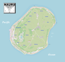
Due to being surrounded by corals and sandy beaches, the island houses no natural harbours, nor any rivers or substantial lakes.
From mid-Eocene (35mya) to Oligocene times, a submarine volcano built up over a hotspot and formed a seamount composed of basalt.
The volcano was eroded to sea level and a coral atoll grew on top to a thickness of about 500 metres.
Freshwater can be found in Buada lagoon, and also in some brackish ponds at the escarpment base in Ijuw and Anabar in the northeast.
[4] Nauru is a party to the international environmental agreements on biodiversity, climate change, desertification, the law of the sea and marine dumping.
Annual rainfall is highly variable and is influenced by the El Niño–Southern Oscillation, with several significant recorded droughts.