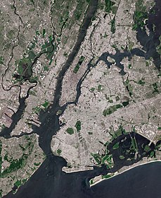
Geography of New York City
The geography of New York City is characterized by its coastal position at the meeting of the Hudson River and the Atlantic Ocean in a naturally sheltered harbor.
Environmental issues are chiefly concerned with managing this density, which also explains why New York is among the most energy-efficient and least automobile-dependent cities in the United States.
[7] The boroughs of New York City straddle the border between two geologic provinces of eastern North America.
The Bronx and Manhattan lie on the eastern edge of the Newark Basin, a block of the Earth's crust which sank downward during the disintegration of the supercontinent Pangaea during the Triassic period.
The Palisades Sill on the New Jersey shore of the Hudson River exposes ancient, once-molten rock that filled the basin.
New York City plays an important role in the green policy agenda because of its size.
Environmental groups make large efforts to help shape legislation in New York because they see the strategy as an efficient way to influence national programs.
Manufacturers are also attuned to the latest trends and needs in the city because the market is simply too big to ignore.