Geography of Norway
This is a slow process, and for thousands of years following the end of the ice age, the sea covered substantial areas of what is today dry land.
[citation needed] Mainland Norway comprises an extensive range of natural variation, given its moderate size, including both terrestrial, marine, limnic and snow and ice ecosystems.
[5] Glaciated; mostly high plateaus and rugged mountains broken by fertile valleys; small, scattered plains; coastline deeply indented by fjords; arctic tundra only in the extreme northeast (largely found on the Varanger Peninsula).
Starting with Setesdalsheiene north of the Skagerrak coast, the mountains are found in large parts of the country and intersect the many fjords of Vestlandet.
The mountain chain swings eastwards south of Trondheim, with ranges such as Dovrefjell and Rondane, and reaches the border with Sweden, where they have become mostly gently sloping plateaus.
The Scandinavian mountains form the Lyngen Alps, which reach into northwestern Finnmark, gradually becoming lower from Altafjord towards the North Cape, where they finally end at the Barents Sea.
The land further north in Northern Norway (corresponding to Nordland, Troms, and northwestern Finnmark) is again dominated by steep mountains going all the way to the coast and by numerous fjords.
On the eastern coast of the Svalbard archipelago, the sea used to be frozen during most of the year, but warming has led to open waters lasting noticeably longer.
Atlantic lows bringing mild winds in winter further warmed by foehn can give warm temperatures in narrow fjords in winter, Compared to coastal areas, inland valleys and the innermost fjord areas have larger diurnal temperature variations, especially in spring and summer.
[citation needed] Tsunamis have killed people; usually caused by parts of mountains (rockslide) falling into fjords or lakes.
This happened 1905 in Loen in Stryn Municipality when parts of Ramnefjell fell into Loenvatnet lake, causing a 40-metre (130 ft) tsunami which killed 61 people.
Recent research using DNA-studies of spruce and pine and lake sediments have proven that Norwegian conifers survived the ice age in ice-free refuges to the north as far as Andøya.
[17] Some plants, such as holly and bell heather, are classified as western due to their need for high humidity or low tolerance of winter frost; these will stay close to the southwestern coast, with their northern limit near Ålesund.
There are species which seem to thrive in between these extremes, such as the southern plants, where both winter and summer climate is important (such as pedunculate oak, European ash, and dog's mercury).
[18] Planted deciduous trees, such as horse chestnut and beech, thrive north of the Arctic Circle (as at Steigen Municipality).
These species cannot tolerate summers that are comparatively long and warm, nor are they able to compete with plants adapted to a longer and warmer growing season.
Some nemoral species in this zone are English oak, sessile oak, European ash, elm, Norway maple, hazel, black alder, lime, yew, holly (southwest coast), wild cherry, ramsons, beech (a late arrival only common in Vestfold), and primrose.
Typical boreal species are Norway spruce, pine, downy birch, grey alder, aspen, rowan, wood anemone, and Viola riviniana.
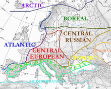
The area dominated by spruce forests (some birch, pine, willow, aspen) mostly belong to the Scandinavian and Russian taiga ecoregion (PA0608).
[20] This ecoregion thus shows a very large range of climatic and environmental conditions, from the temperate forest along the fjords of Western Norway to the summit of Galdhøpiggen, and northeast to the Varanger Peninsula.
Birch is usually dominant in these northern areas; but pine, aspen, rowan, bird cherry and grey alder are also common.
The last patch of NB zone gives way to tundra at sea level about 10 kilometres (6.2 mi) south of the North Cape plateau (near Skarsvåg).
Alpine tundra is common in Norway, covering a total of 32% of the land area (excluding Svalbard and Jan Mayen) and belonging to the Scandinavian Montane Birch forest and grasslands ecoregion (PA1110).
The highest weather station in Norway—Fanaråken in Luster Municipality, at 2,062 metres (6,765 ft)—has barely three months of above freezing temperatures and a July average of 2.7 °C (36.9 °F).
[24] In addition to oil and natural gas, hydroelectric power, and fish and forest resources, Norway has reserves of ferric and nonferric metal ores.
Norway's resources include petroleum, copper, natural gas, pyrites, nickel, iron ore, zinc, lead, fish, lumber, and hydropower.
In 2008, Environment Norway (Miljøstatus) referred changing land use as one of the most important factors for endangered species and declining biodiversity.
[27] Environmental concerns in Norway include how to cut greenhouse gas emissions, pollution of the air and water, loss of habitat, damage to cold-water coral reefs from trawlers, and salmon fish farming threatening the wild salmon by spawning in the rivers, thereby diluting the fish DNA.
Acid rain has damaged lakes, rivers and forests, especially in the southernmost part of the country, and most wild salmon populations in Sørlandet have died.
Winters will probably be significant milder, and the sea-ice cover in the Arctic Ocean might melt altogether in summer, threatening the survival of the polar bear on Svalbard.