Geography of Romania
It is bordered on the Black Sea, the country is halfway between the equator and the North Pole and equidistant from the westernmost part of Europe—the Atlantic Coast—and the most easterly—the Ural Mountains.
Moldova and Ukraine lie to the east, Bulgaria to the south, and Serbia and Hungary to the west by the Pannonian Plain.
Wallachia reaches south from the Transylvanian Alps to the Bulgarian border and is divided by the Olt River into Oltenia on the west and Muntenia on the east.
Although this acquisition united some 85 percent of the Romanian-speaking population of Eastern Europe into one nation, it left a considerable number of ethnic Hungarians under Romanian rule.
Disputes between Hungary and Romania regarding this territory would surface regularly, as both considered the region part of their national heritage.
They also contain important ore deposits, including gold and silver, and their mineral water springs feed numerous health resorts.
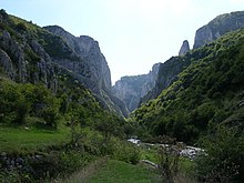
Numerous passes and the valleys of the Olt, Jiu, and Danube rivers provide routes for roads and railways through the mountains.
The Western Romanian Carpathians are the most densely settled, and it is in the northernmost area of this range, the Apuseni Mountains, that permanent settlements can be found at the highest altitudes.
Enclosed within the great arc of the Carpathians lie the undulating plains and low hills of the Transylvanian Plateau—the largest tableland in the country and the center of Romania.
To the south and east of the Carpathians, the Sub-Carpathians form a fringe of rolling terrain ranging from 396 to 1,006 meters in elevation.
Irrigation is widely used, and marshlands in the Danube's floodplain have been diked and drained to provide additional tillable land.
The delta is a triangular swampy area of marshes, floating reed islands, and sandbanks, where the Danube ends its trek of almost 3,000 kilometers and divides into three frayed branches before emptying into the Black Sea.
The Danube Delta provides a large part of the country's fish production, and its reeds are used to manufacture cellulose.
The region also serves as a nature preserve for rare species of plant and animal life including migratory birds.
After entering the country in the southwest at Bazias, the Danube travels some 1,075 kilometers (almost 40% of its entire length) through or along Romanian territory, forming the southern frontier with Serbia and Bulgaria.
In the south, the rivers flow directly into the Danube, and in the west, waters are collected by the Tisza on Hungarian territory.
One of Europe's largest hydroelectric stations is located at the Iron Gates, where the Danube surges through the Carpathian gorges.
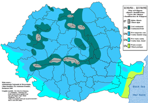
The Carpathians serve as a barrier to Atlantic air masses, restricting their oceanic influences to the west and center of the country, where they make for milder winters and heavier rainfall.
The mountains also block the continental influences of the vast plain to the north in Ukraine, which bring frosty winters and less rain to the south and southeast.