Geography of Saint Kitts and Nevis
Saint Kitts and Nevis is a twin island country with a total landmass of just 270 square kilometres (104 sq mi).
The islands are the summits of a submerged mountain range which forms the eastern boundary of what is known as the Caribbean Tectonic Plate.
The entire island archipelago is geologically young, having begun to form probably less than 50 million years ago, during the Miocene era.
The geology of Nevis can be subdivided into four informal units: Volcanic of the eruptive centers, volcanigenic rocks - pyroclastics and lahars, fluviatile and lacustrine deposits, and raised beaches.
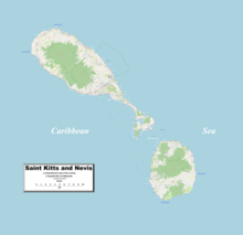
Map references: Central America and the Caribbean Area: total: 261 km2 (Saint Kitts 168 km2; Nevis 93 km2) land: 261 km2 water: 0 km2 Area - comparative: two thirds the size of the island of Barbados Coastline: 135 km Maritime claims: continental shelf: 200 nautical miles (370 km) or to the edge of the continental margin territorial sea: 12 nautical miles (22 km) contiguous zone: 24 nautical miles (44 km) exclusive economic zone: 200 nautical miles (370 km) Climate: tropical tempered by constant sea breezes; little seasonal temperature variation; rainy season (May to November) Extreme points: Northernmost point: Unnamed headland at Dieppe Bay Town, Saint Kitts Southernmost point: Devil's Cave, Saint John Figtree Parish, Nevis Westernmost point: Western cape of Saint Kitts, Saint Anne Sandy Point Parish Easternmost point: Eastern cape of Nevis, Saint James Windward Parish lowest point: Caribbean Sea 0 m highest point: Mount Liamuiga 1,156 m Natural resources: arable land Land use: arable land: 19.44% permanent crops: 2.78% other: 77.78% (2005) Natural hazards: hurricanes (July to October) Environment - international agreements: party to: Biodiversity, Climate Change, Desertification, Endangered Species, Hazardous Wastes, Law of the Sea, Ozone Layer Protection, Ship Pollution, Whaling By the Köppen climate classification, St. Kitts has a tropical savanna climate (Köppen Aw) and Nevis has a tropical monsoon climate (Köppen Am).