Climate of the United States
The climate of the United States varies due to changes in latitude, and a range of geographic features, including mountains and deserts.
In the Northern Hemisphere summer, the subtropical high pressure systems move northward and closer to the United States mainland.
The polar jet stream (and associated conflict zone between cold, dry air masses from Canada and warm, moist air masses from the Gulf of Mexico) drops further southward into the United States – bringing more frequent periods of stormy weather, with rain, ice and snow, and much more variable temperatures, with rapid temperature rises and falls not uncommon.
From May to August especially, often-overnight mesoscale-convective-system (MCS) thunderstorm complexes, usually associated with frontal activity, can deliver significant to flooding rainfall amounts from the Dakotas/Nebraska eastward across Iowa/Minnesota to the Great Lakes states.
Cities like Phoenix, Las Vegas, Yuma, and Palm Springs have average highs over 100 °F (38 °C) during the summer months and lows in the 70s or even 80s.
Forest fires across the Western United States (especially the southwest) occur many years, and can be severe to extreme in especially hot, dry summer seasons.
As in other temperate desert climates, the dry air results in large differences (sometimes over 40 degrees) between daytime high and nighttime low temperatures.
Precipitation, though scarce, often falls year-round, influenced both by summer thunderstorms brought by the Southwestern monsoon (primarily in southern areas), and by winter-season storms from the Pacific Ocean.
Upwelling of cold Pacific waters also contributes to the frequent cool spring and early summer weather in coastal California.
In California's inland river valleys (Bakersfield, Sacramento areas), the wet-winter, dry-summer pattern remains, but winters are cooler and more prone to occasional frost or freeze, while summers are much hotter, with blazing sunshine and daytime high temperatures not uncommonly in the 90s to over 100 °F (38 °C).
In the interior South, in cities like Raleigh, Atlanta, Birmingham, Nashville, Lexington, and Jackson, average summer highs and lows are similar to coastal areas, while some areas of interior eastern and central Texas (i.e. Dallas, Austin and San Antonio areas) have average daily highs in the mid to upper 90s F. In winter, average daily high temperatures range from the 40 °F (4 °C)s (upper South: northern Arkansas, Kentucky and Virginia), to the 60 °F (16 °C)s along the Gulf Coast and South Atlantic coast (Charleston southward), with 70 °F (21 °C)s in central Florida and far southern Texas.
However, occasionally frozen precipitation (snow, sleet and/or freezing rain) can occur (more commonly in interior and northern areas) when southerly-tracking storms throw Gulf or Atlantic moisture over cold air at ground level.
In cities like Fort Lauderdale, Miami, Key West, Naples, and Palm Beach average daily highs range from the mid 70 °F (21 °C)s in winter to near 90 °F (32-33 °C) in summer.
Far western Texas (El Paso area) is desert, and average annual precipitation is less than twenty inches (510 mm) in westernmost Kansas and the Oklahoma Panhandle, where the climate qualifies as semi-arid.
Cities in this area include Minneapolis, Omaha, Sioux Falls, Fargo, Chicago, Cleveland, Buffalo, Albany, Boston, Concord and Augusta.
In the upper Midwest and northern Plains states, temperatures may rise or fall rapidly, and winds (from warm-season thunderstorms or larger-scale low-pressure systems) can be strong to extreme.
The conflicts between Canadian and Gulf air commonly produce severe thunderstorms (including hailstorms, especially on the western Plains) and tornadoes, particularly in May and June.
In the northern Plains and North Central states generally, June is the year's wettest month on average, owing to maximum shower and thunderstorm activity.
[citation needed] In winter, the Pacific Northwest (especially coastal districts and other areas west, i.e. on the prevailing windward side, of the Olympic and Cascade mountain ranges), experiences a mostly overcast, wet and cool climate, but without severe cold like that found in the interior northern U.S. (i.e. Minnesota/North Dakota).
The Great Basin and Columbia Plateau (the Intermontane Plateaus) are arid or semiarid regions, with high summer temperatures in the 90s to occasionally over 100 at lower elevations (e.g. at Boise, Idaho), with annual precipitation averaging less than 15 inches (380 mm) as a result of the rain shadow of the Sierra Nevada and Cascades.
[citation needed] Both coastal and interior areas of Oregon and Washington, and southern Idaho, have a wet-winter, dry-summer precipitation pattern, but traveling eastward into Montana and Wyoming, this transitions progressively (for example, at Missoula, Montana) toward relatively drier winters and a May and eventually June precipitation maximum, the latter characteristic of the Northern Plains and much of the upper Midwest (i.e. both Dakotas, Nebraska, Iowa and Minnesota).
Lower elevations in interior Alaska, such as the Yukon Flats and the Tanana Valley experience extreme cold in the winter as well as high summertime temperatures.
The U.S. Virgin Islands have a tropical savanna climate, with warm, dry winters, and rainy summers (Köppen Aw), typical of the Caribbean.
Rainmaker Mountain on Tutuila traps trade-wind rainclouds, leading to very high rainfall and a tropical rainforest climate (Köppen Af).
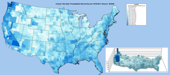
[9] In the central and upper eastern United States, precipitation is evenly distributed throughout the year, although summer rainfall increases as one moves southeastward.
[11] The El Niño-Southern Oscillation affects the precipitation distribution, by altering rainfall patterns across the West, Midwest, the Southeast, and throughout the tropics.
Large thunderstorm areas known as mesoscale convective complexes move through the Plains, Midwest, and Great Lakes during the warm season, contributing up to 10% of the annual precipitation to the region.
Along the coastal mountain ranges in the Pacific Northwest, rainfall is greater than anywhere else in the continental U.S., with Quinault Ranger Station in Washington having an average of 137 inches (3,480 mm).
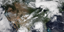
[26] Because of contrasting air masses, the Great Plains, the Midwest, and the southern United States have frequent severe thunderstorms and tornado outbreaks during both the spring and the summer.
The narrow canyons of many mountain areas in the west and severe thunderstorm activity during the monsoon season in summer leads to sometimes devastating flash floods as well.