Geography of Slovenia
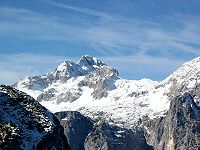
Slovenia is situated at the crossroads of central and southeast Europe, touching the Alps and bordering the Adriatic Sea.
Slovenia's Adriatic coastline stretches approximately 47 km (29 mi) from Italy to Croatia.
On the Pannonian plain to the east and northeast, toward the Croatian and Hungarian borders, the landscape is essentially flat.
However, the majority of Slovenian terrain is hilly or mountainous, with around 90% of the surface 200 meters or more above sea level.
Slovenia's location is where southeastern and Central Europe meet, where the Eastern Alps border the Adriatic Sea between Austria and Croatia.
Since 2016, the geodetic system of Slovenia with the elevation benchmark of 0 m has its origin at the Koper tide gauge station.
The areas are covered mostly by beech, fir-beech and beech-oak forests and have a relatively high production capacity.
Slovenia's terrain and abundance of rivers makes it ideal for hydropower, which is responsible for around a third of the country's electricity production.
[13] Slovenia is not known for large mining operations, but still has some notable deposits: Lignite coal is found primarily in the northeastern part of the country.