Geography of Uruguay
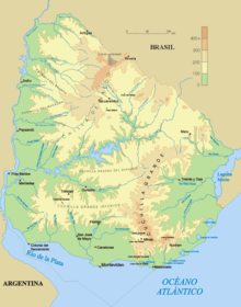
[1] Montevideo, the capital and major port, sits on the banks of the Río de la Plata and is on approximately the same latitude as Cape Town and Sydney.
[1] The remaining three-quarters of the country is a rolling plateau marked by ranges of low hills that become more prominent in the north as they merge into the highlands of southern Brazil.
[1] Northwestern Uruguay, however, is farther from large bodies of water and therefore has warmer summers and milder and drier winters than the rest of the country.
[1] Average highs and lows in summer (January) in Montevideo are 28 and 17 °C (82.4 and 62.6 °F), respectively, with an absolute maximum of 43 °C (109.4 °F); comparable numbers for Artigas in the northwest are 33 and 18 °C (91.4 and 64.4 °F), with the highest temperature ever recorded 42 °C or 107.6 °F.
[1] Averages in July of a high of 18 °C (64.4 °F) and a low of 7 °C (44.6 °F) in Artigas confirm the milder winters in northwestern Uruguay, but even here temperatures have dropped to a subfreezing −4 °C (24.8 °F).
[1] As in most temperate climates, rainfall results from the passage of cold fronts in winter, falling in overcast drizzly spells, and summer thunderstorms are frequent.
[1] A winter warm spell can be abruptly broken by a strong pampero, a chilly and occasionally violent wind blowing north from the Argentine pampas.
[1] This largest region includes the departments of Artigas, Cerro Largo, Durazno, Flores, Florida, Lavalleja, Rivera, Salto, Tacuarembó, and Treinta y Tres and the eastern halves of Paysandú, Río Negro, and Soriano.
[1] Government attempts to encourage agricultural colonization by means of land reform in the interior had largely failed in economic terms, as had the promotion of wheat production.
[1] By contrast, the closure of the famous meat-packing plant at Fray Bentos in the department of Río Negro transformed it into a virtual ghost town.
[1] Farther south, the litoral economy had benefited from completion of the General Artigas Bridge across the Río Uruguay from Paysandú to the Argentine province of Entre Ríos.
[1] However, the advent of a convenient (if circuitous) land route from Montevideo to Buenos Aires via the new bridge reduced freight and passenger traffic through the small port of Colonia on the Río de la Plata just opposite the Argentine capital.
[1] Since the 1950s, Montevideo's prosperous middle classes have tended to abandon the formerly fashionable downtown areas for the more modern high-rise apartment buildings of Pocitos, a beachfront neighborhood east of the center.
[1] Still farther east lies the expensive area of Carrasco, a zone of modern luxury villas that has come to replace the old neighborhood of El Prado in the north of the city as home to the country's wealthy elite.
[1] Starting in the 1970s, the city began to acquire a belt of shantytowns around its outskirts, but in 1990 these remained small compared with Rio de Janeiro or Guayaquil, for example.
[1] Attempts by the military governments from 1973 to 1985 to promote the development of the north of the country (partly for strategic reasons) failed to change this pattern of extreme centralization.
[1] By contrast, the local telephone network in Montevideo remained so hopelessly antiquated and unreliable that many firms relied on courier services to get messages to other downtown businesses.
[1] With its hotels, restaurants, casino, and nightclubs, Punta del Este was a major export earner, and it dominated Uruguay's tourism industry.
[1] Beyond Punta del Este in the still mostly undeveloped department of Rocha, a number of communities had sprouted along the unspoiled Atlantic coast with its kilometres of sandy beaches and huge breakers.
[1] Uruguay's regions differed markedly not only in population size and density but also in their indexes of social and economic development, including education, health care, communications, energy consumption, and industrialization.
[1] Somewhat more developed was a band of six departments stretching across the center of the country, from west to east: Río Negro, Flores, Florida, Durazno, Treinta y Tres, and Rocha.
[1] More industrialized and urbanized, but still quite poor, were the departments of Soriano and Salto, which, as noted previously, benefited from the construction of a bridge and a dam, respectively, across the Río Uruguay in the late 1970s and early 1980s.
[1] Three departments close to Montevideo—San José, Canelones, and Lavalleja—presented a contradictory picture of relatively advanced economic development combined with low indexes of social modernization.
[1] Finally, Montevideo and the department of Maldonado (which is strongly affected by the tourism industry in Punta del Este) had the highest indexes of social and economic development in the country.
Overflight and navigation is guaranteed beyond 12 nmi (22.2 km; 13.8 mi) Natural resources: arable land, hydropower, minor minerals, fisheries Irrigated land: 1,180 km2 (2003) Total renewable water resources: 139 km3 (2011) Environment - current issues: water pollution from meat packing/tannery industry; inadequate solid/hazardous waste disposal Environment - international agreements: party to: Antarctic Treaty, Antarctic-Environmental Protocol, Biodiversity, Climate Change, Climate Change-Kyoto Protocol, Desertification, Endangered Species, Environmental Modification, Hazardous Wastes, Kyoto Protocol, Law of the Sea, Ozone Layer Protection, Ship Pollution, Wetlands signed, but not ratified: Marine Dumping, Marine Life Conservation