Geography of the Bahamas
Due to the many widespread islands it has the 41st largest Exclusive Economic Zone of 654,715 km2 (252,787 sq mi).
[1] Pineyards are found on four of the northern islands: Grand Bahama, Great Abaco, New Providence, and Andros.
In the dry season, extending from November through April, the subtropical high retreats, and a mix of drier northeast trade winds and occasional westerlies coming down from the North American mainland impact the Bahamas.
[1] Rainfall often occurs in short-lived, fairly intense, but brief thundershowers accompanied by strong gusty winds, followed by a return to clear skies.
[1] Winds are predominantly easterly throughout the year but tend to become northeasterly from October to April and southeasterly from May to September.
84 people died (74 of which were from the Bahamas), and there was catastrophic damage to buildings, homes, and boats, and sometimes complete destruction.
[15] Global temperature rise of 2 °C above preindustrial levels can increase the likelihood of extreme hurricane rainfall by four to five times in the Bahamas.
[18] The Bahamas is expected to be highly affected by sea level rise because at least 80% of the total land is below 10 meters elevation.
[21] Although the country's greenhouse gas emissions are comparatively small (2.94 million tonnes of green house gases emitted in 2023),[22] the Bahamas is reliant on imported fossil fuels for energy generation.
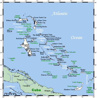
Geographic coordinates (capital city Nassau): 25°4′N 77°20′W As an island nation, the Bahamas is made up of numerous archipelagos, beaches, straits, blue holes, and other landforms.
Notable bodies of water include Dean's Blue Hole, Lake Rosa, and the Goose River.