Geology of India
Different regions of the Indian subcontinent contain rocks belonging to different geologic periods, dating as far back as the Eoarchean Era.
The melting broke through the surface of the craton in a massive flood basalt event, creating the Deccan Traps.
The Damodar and Sone river valleys and Rajmahal hills in eastern India contain a record of the Gondwana rocks.
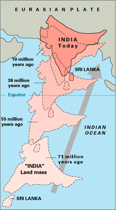
During the Jurassic Period about 160 Ma (ICS 2004), rifting caused Pangaea to break apart into two supercontinents, namely Gondwana (to the south) and Laurasia (to the north).
The Indian Craton remained attached to Gondwana, until the supercontinent began to rift apart about in the early Cretaceous, about 125 million years ago (ICS 2004).
The earliest phase of tectonic evolution was marked by the cooling and solidification of the upper crust of the earth's surface in the Archaean Era (prior to 2.5 billion years) which is represented by the exposure of gneisses and granites especially on the Peninsula.
Minor igneous intrusions, deformation (folding and faulting) and subsequent metamorphism of the Aravalli Mountains represent the main phase of orogenesis.
These basins which border or lie within the existing crystalline basement, were uplifted during the Cambrian (500 Ma (ICS 2004)).
Indirect evidence for the age of the Upper Vindhyan was discussed by Meert and Pandit (2015) who noted the similarity in paleomagnetic directions from the 1073 Ma Majhgawan kimberlite, the 1.1 Ga Mahoba dyke and sediments of the Bhander and Rewa Groups.
In addition, multiple detrital zircon studies failed to isolate any ages younger than ~1000 Ma from Upper Vindhyan rocks.
Early Paleozoic rocks are found in the Himalayas and consist of southerly derived sediments eroded from the crystalline craton and deposited on the Indian platform.
In the Late Paleozoic, Permo-Carboniferous glaciations left extensive glacio-fluvial deposits across central India, in new basins created by sag/normal faulting.
At this time, prior to the Deccan eruptions, uplift in southern India resulted in sedimentation in the adjacent nascent Indian Ocean.
At the close of the Mesozoic one of the greatest volcanic eruptions in earth's history occurred, the Deccan lava flows.
Covering more than 500,000 square kilometres (193,051 sq mi) area, these mark the final break from Gondwana.
The upper crustal shortening is documented from the geological record of Asia and the Himalaya as up to approximately 2,350 km (1,460 mi) less.
The rocks of the Dharwar system are mainly sedimentary in origin,[8] and occur in narrow elongated synclines resting on the gneisses found in Bellary district, Mysore and the Aravalis of Rajputana.
Rocks of the earliest part of the Cambrian Period are found in the Salt range in Punjab and the Spiti area in the central Himalayas and consist of a thick sequence of fossiliferous sediments.
In many places Carboniferous strata are overlaid by grey agglomeratic slates, believed to be of volcanic origin.
In the central provinces, the well developed beds of Lameta contain fossil records which are helpful in estimating the age of the Deccan Traps.
These rocks are a source of high quality building stone and also provide a very fertile clayey loam, particularly suited to cotton cultivation.
[9] A similar earthquake in a densely populated area today would kill hundreds of thousands if not millions.
The major reason for the high frequency and intensity of the earthquakes is that the Indian plate is driving into Asia at a rate of approximately 47 mm/year.
A World Bank & United Nations report shows estimates that around 200 million city dwellers in India will be exposed to storms and earthquakes by 2050.
[11] National Disaster Management Authority says that 60% of Indian landmass is prone to earthquake and 8% susceptible to cyclone risks.