Geology of Monmouthshire
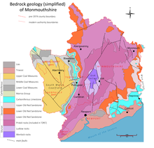
The geology of Monmouthshire in southeast Wales largely consists of a thick series of sedimentary rocks of different types originating in the Silurian, Devonian, Carboniferous, Triassic and Jurassic periods.
The oldest rocks, of Silurian age, occur as a broad, northeast to southwest aligned anticline in the heart of the county.
Similar though smaller outcrops of Jurassic rocks can be found at Goldcliff on the Severn Estuary and also, concealed beneath more recent sediments, near the mouth of the Ebbw River south of Newport.
These rocks consist of a thick sequence (over 600m / 2000 ft) assigned to the Přídolí, Ludlow and Wenlock series.
All of these rocks are of marine origin, their lithologies suggestive of a variety of deep and shallow water environments during deposition.
The uppermost Silurian rocks are the Downton Castle Sandstone and the overlying Raglan Mudstones, both of Přídolían age.
The Brownstones also give rise to a major landscape feature in eastern Monmouthshire, a sinuous though largely unbroken west and northwest-facing escarpment which runs from the Wye Valley at Monmouth south and southwest to Newport and forming the hills at Trellech, Devauden and at Wentwood.
The limestone of South Wales is subdivided into a number of individual formations, not all of which are present in Monmouthshire and some that are, are notably thinner here than is the case further to the west.
The Coal Measures occupy the majority of the western part of the historic county, today's Caerphilly and Blaenau Gwent unitary districts and half of Torfaen.
The origins of the deeply incised gorge of the River Wye which forms Monmouthshire's eastern border continue to be discussed.
One proposal, that of superimposed drainage is that during the Jurassic and Cretaceous periods, sedimentary rocks similar in part to those found in the Cotswolds, were laid down across the area, burying the older Carboniferous Limestone.
During the succeeding Tertiary period, an early version of the Wye flowed across the area, which at that time formed a flat coastal plain, and developed large meanders as it did so.
When the land in the area subsequently began to rise relative to sea level the river was able to maintain its course by cutting down into its bed, so incising its course.
Small areas of karst landscape have developed where the Carboniferous Limestone is present at or near the ground surface, notably from the eastern margins of Mynydd Llangatwg through Gilwern Hill to Blorenge.
[13] Landslips are common on the steep sides of the coalfield valleys where a combination of glacial over-deepening and the presence of the Pennant Sandstone overlying weaker mudstones has provided favourable conditions for ground movement.
On the northeastern fringe of the coalfield, there are slips in the vicinity of Blorenge, the most well-known of which is the Tumble through which the B4246 road climbs towards Keeper's Pond.
A notable example of mass movement is Mynydd Henllys, west of Cwmbran where a large section of the mountain has slipped northwestwards into the post-glacially deepened valley of the Nant Cam, leaving a 2 km long degraded fissure feature high on the eastern slopes.
It owes its origin to a mass of sandstone slipping in rotational fashion on a surface approximating to the Brithdir coal seam and associated mudstones and seatearths.
Smaller slips are evident on the northern slopes of the Sugar Loaf though the largest on that hill is at Graig where a spur extends towards the River Usk.
Cwmyoy village famous for the crooked nature of St Martins Church sits on a landslip extending down from Hatterrall Hill which is still moving, albeit slowly.
Further east in lowland Monmouthshire, though affecting the same rock strata, landslips are recorded around Graig Syfyrddin and towards the Monnow valley as at Coed y Pwll northwest of Skenfrith.
Two significant examples are seen between St Arvans and Tintern where Black Cliff and Wyndcliff represent the back walls of broad slips which extend down to the riverbank.
It sits atop the less competent strata of the Avon Group (traditionally the 'Lower Limestone Shale') which has collapsed under the loading.
The Coalfield rivers show similarly restricted floodplain development, occupying as they do, valleys which have been cut largely by glacial action.
A high profile example is that of the Canada Tips, an area of excavation and deposition of Coal Measures rocks north of Blaenavon associated in particular with opencasting during the Second World War.
The combination of towering limestone cliffs, wooded hillsides and cultural items such as Tintern Abbey contributed to the perceived sublime nature of the area.
Monmouthshire extends into the easternmost part of the South Wales Coalfield and accordingly there was historically considerable extractive industry in that area associated not just with coal mining but also workings for ironstone and indeed for limestone.