Geology of Great Britain
As a result of its eventful geological history, Great Britain shows a rich variety of landscapes across the constituent countries of England, Wales and Scotland.
These rocks are thought to underlie much of Great Britain (although boreholes have only penetrated the first few kilometres), but next appear extensively at the surface in Brittany and the Channel Islands.
The complexity of Great Britain's geology is due ultimately to its being subject to a variety of plate tectonic processes over a very extended period of time.
These are essentially the remains of folded sedimentary rocks that were originally 25 km thick, deposited over the gneiss on what was then the floor of the Iapetus Ocean.
In the early Cambrian period, the volcanoes and mountains of England and Wales were eroded as the land became flooded by a rise in sea level, and new layers of sediment were laid down.
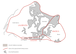
Five hundred million years ago, in the Ordovician period, southern Great Britain, the east coast of North America and south-east Newfoundland broke away from Gondwana to form the continent of Avalonia, which by 440 Ma had drifted (by the mechanisms of plate tectonics) to about 30° south.
The rocks of marine origin in the county of Devon gave the period its name, though deposits of this age are found in many other places, such as the Brecon Beacons, the Midland Valley of Scotland, and the Orkney Islands.
The Caledonian mountains had largely been eroded away by the end of the period during which the country would have experienced an arid desert climate as it was located close to the equator at between 10° and 15° south.
Around 360 Ma, at the start of the Carboniferous period, Great Britain was lying at the equator, covered by the warm shallow waters of the Rheic Ocean, during which time the Carboniferous Limestone was deposited, as found in the Mendip Hills, north and south Wales, in the Peak District of Derbyshire, north Lancashire, the northern Pennines and southeast Scotland.
The mountain building period known as the Variscan orogeny, which occurred around 280 Ma, caused major deformation in south west England.
Towards the end of this period granite was formed beneath the overlying rocks of Devon and Cornwall, now exposed at Dartmoor and Bodmin Moor, giving rise to mineralised deposits of copper and tin.
The Permian was characterised for 30 million years by arid desert conditions and the erosion of the land that had uplifted in the Variscan Orogeny, southwest England and adjacent areas of the present-day English Channel.
Later, much of Great Britain was submerged in shallow waters as the polar ice sheets melted and the Tethys Ocean and Zechstein Sea formed, depositing shale, limestone, gravel, and marl, before finally receding to leave a flat desert with salt pans.
The remnants of the Variscan uplands in France to the south were eroded down, resulting in layers of the New Red Sandstone being deposited across central England, and in faulted basins in Cheshire and the Irish Sea.
With much of Great Britain under water again, sedimentary rocks were deposited and can now be found outcropping across much of England from the Cleveland Hills of Yorkshire to the Jurassic Coast in Dorset.
Chalk was deposited over much of Great Britain, now notably exposed at the White Cliffs of Dover and the Seven Sisters, and also forming Salisbury Plain.
The high sea levels left only small areas of land exposed, which accounts for the general lack of land-origin sand, mud or clay sediments found from around this time.
The major eruptions at this time produced the Antrim Plateau, the basaltic columns of the Giant's Causeway and the lavas and igneous intrusions of the Inner Hebrides of Scotland.
The uplifted areas were then eroded, and further sediments, such as the London Clay, were deposited over southern England, while the English Channel was characterised by mud flats and river-deposited sands.
Evidence from the Brassington Formation suggests that, in the middle and late Miocene (12 to 7 million years ago) a diverse warm-temperate forest grew in the UK.
[3][4][5] The oldest Neogene sediments have been reported from Wales and include fossil pollen that shows a subtropical mixed forest once grew on Anglesey.
[6] The climate of the UK cooled and became drier throughout the Neogene [7][8] The major changes during the Pleistocene were brought about by several recent ice ages.
There is extensive evidence in the form of stone tools that southern England was colonised by human populations during the warm Hoxnian Stage that followed the Anglian Glaciation.
A wide variety of stone has been worked for building and general construction needs (e.g. sand and gravel) while other minerals have been mined or quarried for the chemical industry (e.g. salt), the production of metals (e.g. copper and tin) or other uses (e.g. china clay).


This cross section shows what would be seen in a deep cutting nearly E. and W. across England and Wales. It shows also how, in consequence of the folding of the strata and the cutting off of the uplifted parts, old rocks which should be tens of thousands of feet down are found in borings in East Anglia only 1000 feet or so below the surface.