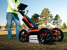
Ground-penetrating radar
It is a non-intrusive method of surveying the sub-surface to investigate underground utilities such as concrete, asphalt, metals, pipes, cables or masonry.
[1] This nondestructive method uses electromagnetic radiation in the microwave band (UHF/VHF frequencies) of the radio spectrum, and detects the reflected signals from subsurface structures.
GPR can have applications in a variety of media, including rock, soil, ice, fresh water, pavements and structures.
When the energy encounters a buried object or a boundary between materials having different permittivities, it may be reflected or refracted or scattered back to the surface.
The electrical conductivity of the ground, the transmitted center frequency, and the radiated power all may limit the effective depth range of GPR investigation.
Cross borehole GPR has developed within the field of hydrogeophysics to be a valuable means of assessing the presence and amount of soil water.
A patent for a system using radar pulses rather than a continuous wave was filed in 1926 by Dr. Hülsenbeck (DE 489 434), leading to improved depth resolution.
GPR was often used on the Channel 4 television programme Time Team which used the technology to determine a suitable area for examination by means of excavations.
[10] A recent novel approach to vehicle localization using prior map based images from ground penetrating radar has been demonstrated.
Termed "Localizing Ground Penetrating Radar" (LGPR), centimeter level accuracies at speeds up to 100 km/h (60 mph) have been demonstrated.
In the field of cultural heritage GPR with high frequency antenna is also used for investigating historical masonry structures, detecting cracks and decay patterns of columns and detachment of frescoes.
[17] Conyers published research using GPR in El Salvador in 1996,[18] in the Four Corners region Chaco period in southern Arizona in 1997,[19][20] and in a medieval site in Ireland in 2018.
[21] Informed by Conyer's research,[17] the Institute of Prairie and Indigenous Archaeology at the University of Alberta, in collaboration with the National Centre for Truth and Reconciliation, have been using GPR in their survey of Indian Residential Schools in Canada.
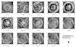
[22] By June 2021, the Institute had used GPR to locate suspected unmarked graves in areas near historic cemeteries and Indian Residential Schools.
[22] On May 27, 2021, it was reported that 215 unmarked anomalies (possibly children's graves) were found using GPR at a burial site at the Kamloops Indian Residential School on Tk’emlúps te Secwépemc First Nation land in British Columbia.
[23] In June 2021, GPR technology was used by the Cowessess First Nation in Saskatchewan to locate 751 unmarked gravesites on the Marieval Indian Residential School site, which had been in operation for a century until it was closed down in 1996.
[24] Advancements in GPR technology integrated with various 3D software modelling platforms generate three-dimensional reconstructions of subsurface "shapes and their spatial relationships".
It employs a geophysical method similar to ground-penetrating radar and typically operates at frequencies in the MF, HF, VHF and UHF portions of the radio spectrum.
The depth to a target is determined based on the amount of time it takes for the radar signal to reflect back to the unit’s antenna.
Depth penetration of this kind of radar is rather small (20–30 cm), but lateral resolution is enough to discriminate different types of landmines in the soil, or cavities, defects, bugging devices, or other hidden objects in walls, floors, and structural elements.
The "Mineseeker Project" seeks to design a system to determine whether landmines are present in areas using ultra wideband synthetic aperture radar units mounted on blimps.
Wall-penetrating radar can read through non-metallic structures as demonstrated for the first time by ASIO and Australian Police in 1984 while surveying an ex Russian Embassy in Canberra.