Georges River
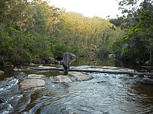
From its source east of Appin within heath habitat of Wollondilly Shire and Wollongong Local government area, the Georges River flows north through rugged sandstone gorges to the east of Campbelltown, roughly parallel to the Main South railway line, with its eastern bank forming a boundary of Holsworthy Army Base.
At Glenfield it reaches the urban environment and then travels to Liverpool where the river turns east and flows past the suburbs of East Hills, Lugarno, and Blakehurst, before emptying into Botany Bay at Taren Point/Sansouci in the southern suburbs of Sydney, where it joins with the estuarine catchment.
The banks of the river along the lower reaches are marked by large inlets and indentations overlooked by steep sandstone ridges and scarps, many being home to expensive residential properties.
Liverpool Weir now forms the uppermost tidal limit and presence of salt water on the Georges River.
Arthur Phillip and Philip Gidley King, leading a party of seamen from the First Fleet rowing two open boats, explored the 'South-West Arm of Botany Bay' (now Georges River).
They are now thought to have gone as far as Lime Kiln Bay, where they landed at two locations there, the first of which they called 'Lance Point'—thought to be modern-day Gertrude Point, Lugarno—where an altercation with local people occurred.
Not finding enough freshwater, around Botany Bay and its two 'arms', the colonists moved on to Port Jackson, where the settlement of Sydney began six days later.
In February 2007, Liverpool and Campbelltown City Council were awarded a $2 million grant from the NSW Environmental Trust under their Urban Sustainability Initiative.
[15] Since the 2010s, the Mandaean community in the Greater Sydney region has been using the Georges River for their ritual baptisms, called masbuta.