Limes Germanicus
The frontier used either a natural boundary such as a river or typically an earth bank and ditch with a wooden palisade and watchtowers at intervals, and a system of linked forts was built behind them.
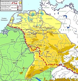
These two major rivers afforded natural protection from mass incursions into imperial territory, with the exception of a gap stretching roughly from Mogontiacum (now Mainz) on the Rhine to Castra Regina.
The potentially weakest, hence most heavily guarded, part of the Limes was the aforementioned gap between the westward bend of the Rhine at modern-day Mainz and the main flow of the Danube at Regensburg.
This 300-kilometre-wide (190 mi) land corridor between the two great rivers permitted movement of large groups of people without the need for water transport, hence the heavy concentration of forts and towers there, arranged in depth and in multiple layers along waterways, fords, roads, and hilltops.
Beyond these rivers she held only the fertile plain of Frankfurt, opposite the Roman border fortress of Moguntiacum (Mainz), the southernmost slopes of the Black Forest and a few scattered bridge-heads.
The motives alike of geographical convenience and of the advantages to be gained by recognising these movements of Roman subjects combined to urge a forward policy at Rome, and when the vigorous Vespasian had succeeded Nero, a series of advances began which gradually closed up the acute angle, or at least rendered it obtuse.
He pushed out from Moguntiacum, extended the Roman territory east of it and enclosed the whole within a systematically delimited and defended frontier with numerous blockhouses along it and larger forts in the rear.
We do not, however, know its date, save that, if not Domitian's work, it was carried out soon after his death, and the whole frontier thus constituted was reorganised, probably by Hadrian, with a continuous wooden palisade reaching from Rhine to Danube.
It consists, as we see it today, of two distinct frontier works, one, known as the Pfahlgraben, is a palisade of stakes with a ditch and earthen mound behind it, best seen in the neighbourhood of the Saalburg but once extending from the Rhine southwards into southern Germany.
But we know that the pressure of the barbarians began to be felt seriously in the later part of the second century, and after long struggles the whole or almost the whole district east of the Rhine and north of the Danube was lost, seemingly all within one short period, about 250.
Germanic invasions in the late third century led to the abandonment of the so-called "Upper Raetian Limes" in favour of a Roman defence line along the rivers Rhine, Iller and Danube (Donau-Iller-Rhine-Limes).
Watch towers were in sight contact and heavily fortified castra placed at important passes (e.g. Castrum Rauracense instead of the previously unwalled Augusta Raurica near to Basel) and in the hinterland of the frontier (e.g. Vindonissa in today's Switzerland).
The limes provided an early warning system, deterrence of casual small-scale raiding, and the ability to counteract attacks while the enemy was still near the border fortresses and garrisons.