Giambattista Nolli
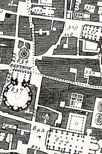
He is best known for his ichnographic plan of Rome, the Pianta Grande di Roma which he began surveying in 1736 and engraved in 1748, and now universally known as the Nolli Map.
It was produced and published in response to the commission of Pope Benedict XIV to survey Rome in order to help create demarcations for the 14 traditional rioni or districts.
[3] It was by far the most accurate description of Rome produced to date at a time when the architectural achievement of the Papacy was in full flower.
Born in 1701[4] in Castiglione d'Intelvi (Como), he moved to Rome thanks to the patronage of members of the patrician Albani and Corsini families.
A scaled-down edition, a collaboration between Nolli and Giovanni Battista Piranesi, was published in the same year the original map was finished.