Retreat of glaciers since 1850
Glaciers also exist in mountain ranges on every continent other than the Australian mainland, including Oceania's high-latitude oceanic island countries such as New Zealand.
Human activities since the start of the industrial era have increased the concentration of carbon dioxide and other heat-trapping greenhouse gases in the air, causing current global warming.
Since higher elevations are cooler, the disappearance of the lowest portion decreases overall ablation, thereby increasing mass balance and potentially reestablishing equilibrium.
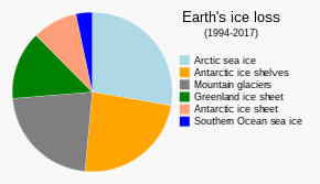
[15][17] Water runoff from melting glaciers causes global sea level to rise, a phenomenon the IPCC terms a "slow onset" event.
[31] One major concern is the increased risk of Glacial Lake Outburst Floods (GLOF), which have in the past had great effect on lives and property.
In 1892 a GLOF released some 200,000 m3 (260,000 cu yd) of water from the lake of the Tête Rousse Glacier, resulting in the deaths of 200 people in the French town of Saint-Gervais-les-Bains.
[38] The Argentière and Mer de Glace glaciers are expected to disappear completely by end of the 21st century if current climate trends persist.
[47] Research, published in 2019 by ETH Zurich, says that two-thirds of the ice in the glaciers of the Alps is doomed to melt by the end of the century due to climate change.
[65] In the more maritime and generally wetter Russian Far East, Kamchatka, exposed during winter to moisture from the Aleutian Low, has much more extensive glaciation totaling around 906 km2 (350 sq mi) with 448 known glaciers as of 2010.
In the Chukotskiy Peninsula small alpine glaciers are numerous, but the extent of glaciation, though larger than further west, is much smaller than in Kamchatka, totaling around 300 square kilometres (120 sq mi).
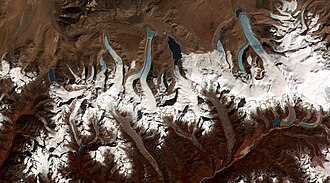
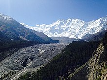
An estimated 15,000 glaciers can be found in the greater Himalayas, with double that number in the Hindu Kush and Karakoram and Tien Shan ranges, and comprise the largest glaciated region outside the poles.
A growing concern is the potential for GLOFs researchers estimate 21 glacial lakes in Nepal and 24 in Bhutan pose hazards to human populations should their terminal moraines fail.
[88] Tajikistan and neighboring countries of the Pamir Range are highly dependent upon glacial runoff to ensure river flow during droughts and the dry seasons experienced every year.
The continued demise of glacier ice will result in a short-term increase, followed by a long-term decrease in glacial melt water flowing into rivers and streams.
[89] North American glaciers are primarily located along the spine of the Rocky Mountains in the United States and Canada, and the Pacific Coast Ranges extending from northern California to Alaska.
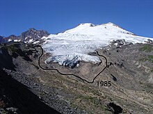
Excepting Alaska, about half of the glacial area in the U.S. is contained within the over 700 glaciers of the North Cascades, a portion of those located between the Canada–US border and I-90 in central Washington.
These contain as much water as is found in all the lakes and reservoirs in the rest of the state, and provide much of the stream and river flow in the dry summer months, approximating some 870,000 m3 (1,140,000 cu yd).
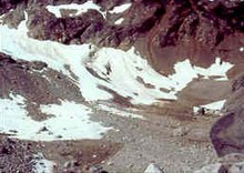
The semiarid climate of Wyoming still manages to support about a dozen small glaciers within Grand Teton National Park, which all show evidence of retreat over the past 50 years.
The Peyto Glacier in Alberta covers an area of about 12 km2 (4.6 sq mi), and retreated rapidly during the first half of the 20th century, stabilized by 1966, and resumed shrinking in 1976.
A large region of population surrounding the central and southern Andes of Argentina and Chile reside in arid areas that are dependent on water supplies from melting glaciers.
[122] Indeed, a study published in 2015 on glacial underwater topography at 3 sites found cavities, due to warm subglacial water intrusion, which has been identified as a possible dominant force for ablation (surface erosion).
Hence, without better modelling, new observations suggest that past projections of sea level rise attribution from the Greenland Ice Sheet require upward revision.
In 2019 Greenland lost 600 gigaton of ice in two months contributing 2.2 mm to global sea level rise[124] A benefit of glacier melting is resulting deposit of one billion tons of rock flour annually, which has great potential as soil conditioner and for direct air capture of carbon.
[128] Since this time, Canadian Arctic glaciers have experienced a sharp increase in mass loss in response to warmer summer temperature, losing 92 Gt per year between 2007 and 2009 .
[159] A March 2005 report indicated that almost no glacial ice remained on the mountain, and the paper noted this as the first time in 11,000 years that barren ground had been exposed on portions of the summit.
It is expected that due to their proximity to the heavy moisture of the Congo region, the glaciers in the Ruwenzori Range may recede at a slower rate than those on Kilimanjaro or in Kenya.
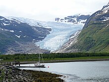
The melting ice has formed a large lake at the front of the glacier since 1983, and bare ground has been exposed for the first time in thousands of years.
The tropical location has a predictably steady level of rain and snowfall, as well as cloud cover year round, and there has been no noticeable change in the amount of moisture which has fallen during the 20th century.
This leaves only the remnants of the once continuous icecap on New Guinea's highest mountain, Mount Carstensz with the 4,884 m (16,024 ft) high Puncak Jaya summit, which is estimated to have had an area of 20 km2 (7.7 sq mi) in 1850.
[178] Reducing greenhouse gas emissions (i.e. climate change mitigation measures) is the only solution that addresses the root cause of glacier retreat since industrialization.


