Glauberg
The Glauberg is a Celtic hillfort or oppidum in Hesse, Germany consisting of a fortified settlement and several burial mounds, "a princely seat of the late Hallstatt and early La Tène periods.
[6] The settlement history of the Glauberg and its area in Celtic times (Hallstatt and early La Tène periods) was the focus of a research project (2004–2006) by the 'Deutsche Forschungsgemeinschaft'.
It combines access to fertile arable land and water with an easily defensible site and a strategic location along several natural traffic routes.
During the Roman occupation of Germany, the Glauberg remained unoccupied, probably due to its proximity (5 km) to the fortified Limes Germanicus border.
Their extent and dimensions mark the Glauberg as one of a network of fortified sites (or oppida) that covered most of south and west central Germany.
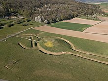
The northeast edge of the hill, where the slope is least severe, was disconnected from the adjacent ground by the erection of a massive ditch and bank, perhaps originally forming a promontory fort.
For this reason, an annex was added to the north, with two walls running downslope, enclosing an additional triangular area of 300 x 300 m, including a spring.
The point of that annex contained a huge water reservoir, measuring 150 by 60 m. At this time, the fortification was 650 m long, nearly 500 m wide, and enclosed an area of 8.5 ha.
For this reason, it was decided to remove the whole chamber en bloque and excavate it more slowly and carefully in the State Service laboratory at Wiesbaden.
The finds from the main burial chamber, each carefully wrapped in cloth, include a fine gold torc and a bronze tubular jug that had contained mead.
They are therefore classed as "princely" burials, on a par with other well-known finds, including those at Vix (Burgundy, France), and Hochdorf (Baden-Württemberg, Germany).
A small square ditch west of the mound is associated with several other features and a number of large postholes, perhaps suggesting a shrine or temple.
The lack of a defensive function and the focus on the burial mounds have led to the suggestion that the enclosure and road system had a ritual or sacred significance.
[11][12] Further analyses have indicated that other ditches and 16 large postholes associated with the burial mound could have been used to observe different astronomical phenomena, such as the solstices, with the whole ensemble functioning as a calendar.
[16] Much international attention was attracted by the 1996 discovery of an extremely rare find, a life-sized sandstone statue or stele, dating from the 5th century BC, which was found just outside the larger tumulus.
Much detail is clearly visible: his trousers, composite armour tunic, wooden shield and a short sword in a scabbard with an anthropomorphic hilt (of La Tène style), hanging from his right side.
The figure has a moustache and wears a torc with three pendants, remarkably similar to the one from the chamber in mound 1, with several rings on both arms and one on the right hand.
As mistletoe is believed to have held a magical or religious significance to the Celts, it could indicate that the individual depicted also played the role of a priest or druid.
[25] The remains of a similar mistletoe-shaped 'leaf crown' have been found at Fiskerton in England dating from c. 450 BC, at the site of a wooden causeway used to make ritual depositions into the Witham river.
Two important fortifications, those at Dünsberg near Giessen and Heidetränk Oppidum (one of the largest urban settlements in Celtic Europe) near Altkönig in the Taunus mountains are visible from Glauberg.
Glauberg must now be considered a proto-urban centre of power, trade and cult, of similar importance to such sites as Bibracte, or Manching, but especially of other "princely" fortified settlements, such as Heuneburg, Hohenasperg and Mont Lassois.
An archaeological park has been built, with the aim of making the site and its context accessible and comprehensible to visitors and providing a space for exhibiting the finds locally.
[36] By November 2015, the museum had counted around 300,000 visitors and estimated the total number of people who had come to see the Keltenwelt (i.e. including those who just explored the 30 ha open air archaeological park) at around 500,000.
