Glen Burnie, Maryland
Glen Burnie is an unincorporated town and census-designated place (CDP) in Anne Arundel County, Maryland, United States.
In 1812, Elias Glenn, a district attorney, established a county seat near what is currently known as Brooklyn Park.
[3] The business flourished during the 19th century, and with it came several thousand acres of land in northern Anne Arundel County.
[citation needed] Upon the death of William Wilkins Glenn, his son, brother and nephew began to manage the family's business affairs, and Glenburnie became an official state subdivision in 1888.
It would not be until 1930 that postmaster Louis J. DeAlba decided two words were better than one, and gave the town a final name change to the current Glen Burnie.
The oldest area church is St. Alban's Episcopal, which was built in 1904, with many of its bricks dating back to Marley Chapel, an early Maryland parish from the 1730s.
[4] Ritchie Highway carried nearly all Baltimore-area traffic headed for Annapolis and the Chesapeake Bay Bridge until an alternate bypass road, Interstate 97, opened in the 1980s.
Until 1950 the Baltimore and Annapolis Railroad provided passenger and freight service through Glen Burnie from Annapolis to Baltimore; passenger service ended in February 1950 due to increased competition from buses and private automobiles, but freight service continued until Hurricane Agnes did so much damage to a trestle crossing the Severn River in Annapolis that the trestle was condemned for use by trains by the Army Corps of Engineers in the late 1960s.
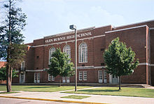
[5] Schools and churches were built in the ensuing decades, and construction was completed on Harundale Mall, the first enclosed shopping center east of the Mississippi River, in 1958.
Charlie Steffey and Jim Rouse negotiated unsuccessfully with the "city fathers" of Glen Burnie, offering to regenerate the (then failing) center of town with their revolutionary concept.
The "city fathers" decided that the advantage of having the "mall" there was overshadowed by the cost of fixing the storm water situation and declined.
[7] The intersection of Central Avenue and Crain Highway forms the boundaries of the NW, SW, NE & SE postal quadrants in the community's center.