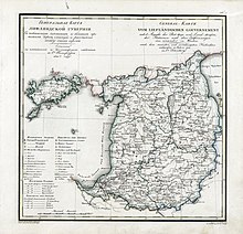
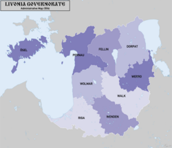
Governorate of Livonia
Until the late 19th century the governorate was not ruled by Russian laws but was administered autonomously by the local German Baltic nobility through a feudal Landtag (Livonian Diet [lv]).
The middle layer of the Devonian system, made up of dolomites, limestone and clay with gypsum and marl, is spread in the southern part of the Livonian province.
Between the rivers Zedde[5] through the Abze and Ogre to the Western Dvina sandstones and sands and partly clay and marl form the upper tier of the Devonian system with the predominance of fish fossils in it.
The coastal formations of the province and the erratic boulders covering its surface belong to the latest, or dilluvial, system: under the former there are calcareous tuffs, peaty marls and marshy iron ores; between the latter crystalline rocks (gneiss, granites and syenites, diorites and porphyries) prevail; fossils of the Silurian period are rare.
Here it is called the Lemsal Plateau; on it is the "Blue Mountain" ( German: Blauberg ), once considered sacred and now still enjoying special respect among Latvians.
The highest point here is Mount Gaising-Kalns, 312 m. The slopes to the Gauja River near Sigulda, Turaida, Krimulda and the banks of the Western Dvina near Selburg and even more Koknese are especially beautiful.
Wooded, covered with meadows, partly peat bogsand the richly irrigated lowlands of the Livland province are located: along the shores of Lake Peipus, around Lake Wirtz-Erva and Pernovskoye - along the shores of the Gulf of Riga and along the basins of the Pernava and Salis rivers, as well as along the lower reaches of the rivers Aa and Zapadnaya Dvina.
- All these lakes are of little commercial and industrial importance for the gubernia so far (except for fishing), but they can be combined into a whole system of water communications, the projects of which have already arisen more than once.
On the coastal strip of the Livonian gubernia the Gulf of Riga forms two harbors, accessible to large ships, although the entrance to them is hampered by bars and the tortuosity of the fairway.
The Baltic Sea on the coasts of the Livonian islands is full of small harbors, but uncomfortable due to the shallow water and many reefs and shoals, except Ahrensburg, which is more convenient and has a good roadstead.
The Livonian Aa, which is floating only for forests and only irrigates most of the southern half of the province in the spring, flows out into the Gulf of Riga.
At the present time, forest management and conservation works have been carried out everywhere in the Livonian province, which, however, started at the end of the last century.
(Valka) (Cēsis) (Valmiera) (Pärnu) (Viljandi) (Kuressaare) (Tartu) The uezds were divided into uchastoks ("subcounties"), which were supervised by assistant chiefs of the district.
[9] After the February Revolution the Russian Provisional Government issued the proclamation on 30 March 1917 "On the autonomy of Estland", according to which the Government of Livonia was divided: five northern counties (Kreis) with the Estonian population (Dorpat, Pernau, Fellin, Werro and Ösel) as well as the populated by the Estonians townships of Walk county were all included into the composition of the neighboring Governorate of Estonia.
The largest segment of the population indicated Latvian to be their mother tongue, with significant Estonian, German, and Russian speaking minorities.
The climate of the Livonian Province had a more continental character than one would expect from its position near the northern Baltic sea, which froze regularly.
The spring temperature was subject to the largest and sharpest fluctuations; the climate of the Livonian Province in general was unstable and the main reason was to be found in the wind which rarely became stormy, but blew almost continuously.
Rains were favorable by quantity, distribution and type; downpours were rare; snow cover was as a rule deep, frequent dense fogs occurred in the coastal strip and in the swampy areas and lowlands.
[citation needed] Riga and Yuriyev characterized the climate of the lower parts of the south and north of the Livonian province.
Mineral wealth - mainly clays, gypsum, peat, swamp ironstone found near the Riga sulphur springs.
Native birds include: eagles, falcons, hawks, crows, magpies, owls, sparrows, pigeons, grouse, snipes and others.
The main objects of fishing are: marine species salakushka, then perch, sturgeon; and in smaller numbers burbot and flounder.
In the sea, salakushka and flounder are caught in great numbers, in Lake Peipus, Virts-Järve, Luban and Burtnekskoe - whitefish, snets, vendace, ruffe, perch, sudak, koryushka and others.
On Lake Peipus there are more than 100,000 fishermen, mostly Russians, catching up to 150,000 barrels of snets alone annually; in the rivers salmon, lamprey (in Dvina).
[11] The Livonian province is very rich in bread products, of which the most used are: rye, barley everywhere, buckwheat in small quantities in the middle and southwestern parts.
Horses are very unsatisfactory; the well- known breed of clapers has almost completely bred and survived only near Fellin, Ober Palen and on the island of Ezele.
The main subject of fishing: the marine species Baltic herring, then perch, sturgeon; in smaller numbers burbot and flounder.
The blazon was, according to the description in Coat of arms of governorates and oblasts of the Russian Empire:[14][15] «В червленом поле серебряный гриф с золотым мечом, на груди, под Императорской короною, червленый вензель: ПВ ИВ (Петр Второй, Император Всероссийский).
The shield was topped with the Imperial crown and surrounded by golden oak leaves tied by the ribbon of the Order of Saint Andrew.
[17] The educational institutions in the province were: 24 newspapers and periodicals are published (12 in Riga, 10 in Yuriev, 2 in Pernov), including several in Estonian and Latvian.