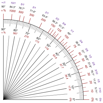
Grade (slope)
The grade (US) or gradient (UK) (also called stepth, slope, incline, mainfall, pitch or rise) of a physical feature, landform or constructed line is either the elevation angle of that surface to the horizontal or its tangent.
Railway gradients are often expressed in terms of the rise in relation to the distance along the track as a practical measure.
In vehicular engineering, various land-based designs (automobiles, sport utility vehicles, trucks, trains, etc.)
The lateral slopes of a highway geometry are sometimes called fills or cuts where these techniques have been used to create them.
In the United States, the maximum grade for federally funded highways is specified in a design table based on terrain and design speeds,[7] with up to 6% generally allowed in mountainous areas and hilly urban areas with exceptions for up to 7% grades on mountainous roads with speed limits below 60 mph (95 km/h).
The steepest roads in the world according to the Guinness Book of World Records are Baldwin Street in Dunedin, New Zealand, Ffordd Pen Llech in Harlech, Wales[8] and Canton Avenue in Pittsburgh, Pennsylvania.
Drawing on the U.S. National Elevation Dataset, 7x7 (magazine) identified ten blocks of public streets in San Francisco open to vehicular traffic in the city with grades over 30 percent.
The steepest at 41 percent is the block of Bradford Street above Tompkins Avenue in the Bernal Heights neighborhood.
[11] The San Francisco Municipal Railway operates bus service among the city's hills.
[12] Likewise, the Pittsburgh Department of Engineering and Construction recorded a grade of 37% (20°) for Canton Avenue.
(A heavily loaded train rolling at 20 km/h on heavy rail may require ten times the pull on a 1% upgrade that it does on the level at that speed.)
In those days, for example, an inspector insisted that Rudgwick railway station in West Sussex be regraded.

Δh = rise
l = slope length
α = angle of inclination