Landslide
Landslides, also known as landslips, skyfalls or rockslides,[3][4][5] are several forms of mass wasting that may include a wide range of ground movements, such as rockfalls, mudflows, shallow or deep-seated slope failures and debris flows.
In many cases, the landslide is triggered by a specific event (such as a heavy rainfall, an earthquake, a slope cut to build a road, and many others), although this is not always identifiable.
[8] Additionally, global warming caused by climate change and other human impact on the environment, can increase the frequency of natural events (such as extreme weather) which trigger landslides.
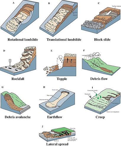
In 1978, geologist David Varnes noted this imprecise usage and proposed a new, much tighter scheme for the classification of mass movements and subsidence processes.
For example, a landslide can initiate as a rock fall or topple and then, as the blocks disintegrate upon the impact, transform into a debris slide or flow.
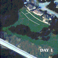
[30] Flowing debris or mud may pick up trees, houses and cars, and block bridges and rivers causing flooding along its path.
As the impoundments fail, a domino effect may be created, with a remarkable growth in the volume of the flowing mass, and in its destructive power.An earthflow is the downslope movement of mostly fine-grained material.
Fissures may develop during the movement of clayey materials, which facilitate the intrusion of water into the moving mass and produce faster responses to precipitation.
The mechanisms favoring the long runout can be different, but they typically result in the weakening of the sliding mass as the speed increases.
Especially for the largest landslides, it may involve the very quick heating of the shear zone due to friction, which may even cause the water that is present to vaporize and build up a large pressure, producing a sort of hovercraft effect.
[36] During the movement, the rock in the shear zone may also be finely ground, producing a nanometer-size mineral powder that may act as a lubricant, reducing the resistance to motion and promoting larger speeds and longer runouts.
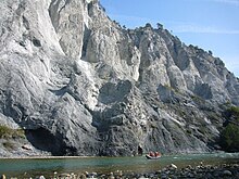
[34] Slides can occur in any rock or soil material and are characterized by the movement of a mass over a planar or curvilinear surface or shear zone.
Typically, debris slides start with the detachment of large rock fragments high on the slopes, which break apart as they descend.
They usually involve deep regolith, weathered rock, and/or bedrock and include large slope failures associated with translational, rotational, or complex movements.
[43][44] Landslide hazard analysis and mapping can provide useful information for catastrophic loss reduction, and assist in the development of guidelines for sustainable land-use planning.
Since many factors are considered for landslide hazard mapping, GIS is an appropriate tool because it has functions of collection, storage, manipulation, display, and analysis of large amounts of spatially referenced data which can be handled fast and effectively.
Before and after aerial photographs and satellite imagery are used to gather landslide characteristics, like distribution and classification, and factors like slope, lithology, and land use/land cover to be used to help predict future events.
GIS offers a superior method for landslide analysis because it allows one to capture, store, manipulate, analyze, and display large amounts of data quickly and effectively.
Because so many variables are involved, it is important to be able to overlay the many layers of data to develop a full and accurate portrayal of what is taking place on the Earth's surface.
Since the ‘90s, GIS have been also successfully used in conjunction to decision support systems, to show on a map real-time risk evaluations based on monitoring data gathered in the area of the Val Pola disaster (Italy).
[63] Instead, they are classified by the sort of slope stabilization method used: The monitoring of landslides is essential for estimating the dangerous situations, making it possible to issue alerts on time, to avoid loses of lives and property, and to have proper planning and reducing measures in place.
Currently, there exist different type of techniques aimed to monitor landslides: •Geophones and accelerometers: Detect seismic vibrations or movements that might indicate slope instability.
This yields negative effects on landslides due to focused infiltration in soil and rock (66) and an increase of runoff events, which may trigger debris flows.