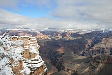
Grand Canyon
President Theodore Roosevelt was a major proponent of the preservation of the Grand Canyon area and visited it on numerous occasions to hunt and enjoy the scenery.
[7][8] While some aspects about the history of incision of the canyon are debated by geologists,[7][9] several recent studies support the hypothesis that the Colorado River established its course through the area about 5 to 6 million years ago.
[7][20] For more than 150 years, scientists have gathered data, proposed new ideas, and debated sometimes contentious theories about the geologic origins of the Grand Canyon and the Colorado River.
Formation of the Grand Canyon and the Colorado River may involve a complex history in which multiple factors and geologic processes have interacted over time and in different locations.
[28][26][29][30] The emerging scientific consensus is that the canyon is made up of multiple segments which formed at different times and eventually connected to become the waterway now traversed by the Colorado River.
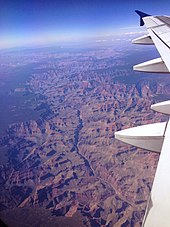
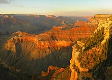
[31][32] The major geologic exposures in the Grand Canyon range in age from the two-billion-year-old Vishnu Schist at the bottom of the Inner Gorge to the 270-million-year-old Kaibab Limestone on the Rim.
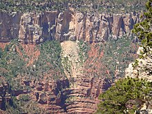
[7] Many of the formations were deposited in warm shallow seas, near-shore environments (such as beaches), and swamps as the seashore repeatedly advanced and retreated over the edge of a proto-North America.
The great depth of the Grand Canyon and especially the height of its strata (most of which formed below sea level) can be attributed to 5,000–10,000 feet (1,500–3,000 m) of uplift of the Colorado Plateau, starting about 65 million years ago (during the Laramide orogeny).
Groundwater from the C-acquifer can flow laterally, appearing as seeps along the canyon walls at the base of the Coconino Sandstone but can also descend vertically through fault zones to recharge the underlying confined R-aquifer.
Fractures are believed to provide dominant pathways both for vertical circulation in the Paleozoic section, and for lateral collection and transport of water to springs deep in the canyons.
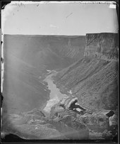
His party reached the lower end of Black Canyon on March 8, 1858, then continued on by rowboat past the mouth of the Virgin River after the Explorer struck a rock.
[57] In his "Report Upon the Colorado River of the West" to the Senate in 1861 Ives states that "The marvellous story of Cardinas, that had formed for so long a time the only record concerning this rather mythical locality, was rather magnified than detracted from by the accounts of one or two trappers, who professed to have seen the cañon".
[65] Powell himself visited the area the following year, and was told (through a Mormon interpreter) that the Shivwits had mistakenly killed the men, believing them to be prospectors who had murdered an Indian woman.
He, his chief engineer Robert Brewster Stanton, and 14 others started to explore the Grand Canyon in poorly designed cedar wood boats, with no life preservers.
The forested rims are high enough to receive winter snowfall, but along the Colorado River in the Inner Gorge, temperatures are similar to those found in Tucson and other low elevation desert locations in Arizona.
Conditions in the Grand Canyon region are generally dry, but substantial precipitation occurs twice annually, during seasonal pattern shifts in winter (when Pacific storms usually deliver widespread, moderate rain and high-elevation snow to the region from the west) and in late summer (due to the North American Monsoon, which delivers waves of moisture from the southeast, causing dramatic, localized thunderstorms fueled by the heat of the day).
[108] Visitors are often surprised by these potentially extreme conditions, and this, along with the high altitude of the canyon's rims, can lead to unpleasant side effects such as dehydration, sunburn, and hypothermia.
Weather conditions can greatly affect hiking and canyon exploration, and visitors should obtain accurate forecasts because of hazards posed by exposure to extreme temperatures, winter storms and late summer monsoons.
[138] The first dual distribution water system in the United States was built on the South Rim, treating and reclaiming wastewater for nonpotable reuse as early as 1926.
Grand Canyon National Park contains 129 vegetation communities, and the composition and distribution of plant species are influenced by climate, geomorphology and geology.
[146] The insect species commonly found in the river corridor and tributaries are midges, caddisflies, mayflies, stoneflies, black flies, mites, beetles, butterflies, moths, and fire ants.
Typical warm desert species such as creosote bush, white bursage, brittlebush, catclaw acacia, ocotillo, mariola, western honey mesquite, four-winged saltbush, big sagebrush, blackbrush, and rubber rabbitbrush grow in this community.
This community is dominated by the four-winged saltbush and creosote bush; other important plants include Utah agave, narrowleaf mesquite, ratany, catclaw acacia, and various cacti species.
[150] The abundance of bats, swifts, and riparian birds provides ample food for peregrines, and suitable eyrie sites are plentiful along the steep canyon walls.
Also, several critically endangered California condors have made the eastern part of the Park their home, having been re-introduced to the Colorado Plateau on the Arizona Strip earlier.
[144] Within this woodland one can find big sagebrush, snakeweed, Mormon tea, Utah agave, banana and narrowleaf Yucca, winterfat, Indian ricegrass, dropseed, and needlegrass.
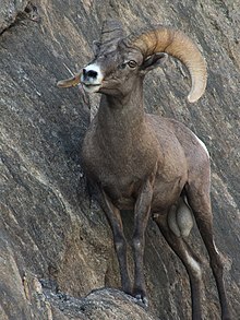
[144] The South Rim includes species such as gray fox, mule deer, bighorn sheep, rock squirrels, pinyon pine, and Utah juniper.
Hiking down to the river and back up to the rim in one day is discouraged by park officials because of the distance, steep and rocky trails, change in elevation, and danger of heat exhaustion from the much higher temperatures at the bottom.
A gondola would enable easy visits to the canyon floor where a "riverwalk" of "connected walkways, an eatery, a tramway station, a seating area and a wastewater package plant" would be situated.
On the morning of June 30, 1956, a TWA Lockheed Super Constellation and a United Airlines Douglas DC-7 departed Los Angeles International Airport within three minutes of one another on eastbound transcontinental flights.