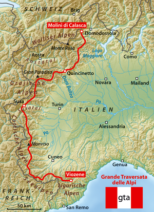
Grande Traversata delle Alpi
The Grande Traversata delle Alpi (GTA) is a long-distance hiking trail in the Italian region of Piedmont.
Day hikes typically connect high-lying valley communities with each other via historic pass routes.
The trail begins in the Pennine Alps; the original plan to let the GTA start on Lago Maggiore has not been implemented due to the lack of suitable accommodations.
The trail then crosses the Varaita, Maira, Grana, Stura di Demonte, Gesso, and Vermenagna Valleys.
The section between Forno and Viozene may be hiked without camping; accommodations are available (posto tappa, with a red-and-white GTA flag), usually with half board.
During the 1990s, a French-Italian joint project published several cross-border 1:50,000-scale maps (with EU support) from the French National Geographic Institute; however, they are out of print.
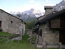
The GTA is a subalpine, montane trail primarily traversing a previously cultivated, densely populated landscape.
Some descendants of original residents, heirs to property, return to the hamlets during summer as a second home; however, most houses have fallen into disrepair.
The GTA often runs along old roads which formerly connected hamlets;[1] mulattieras (mule paths) traversed chestnut forests which were destroyed by a 19th-century blight.
During the second half of the 20th century, there was the decline in regional languages; however, some Occitan speakers still remain in remote valleys.
The GTA originated from a similar trail in France established about 1970, and is part of a network of European long-distance footpaths traversing the Alps.
From 1981 to 1989 a hiking guide was published in book form, and in 1982 a formal tour was organized to publicize the trail.
After a few years interest by Italian hikers waned, and some posti tappa on the eastern route in the southern part closed.