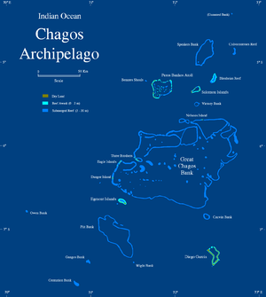
Great Chagos Bank
There are only four emerging reefs, mostly located on the western rim of the atoll, except for lonely Nelson Island, which lies wholly isolated in the middle of the northern fringe.
[2] The total length of the eastern and southern expanses of the bank, as well as the reefs in its central area, are wholly submerged.
The islands of the Great Chagos Bank, starting clockwise from the south, are: The Great Chagos Bank was surveyed for the first time by Commander Robert Moresby of the Royal Indian Navy in 1837; all other maps that would be drawn for over a century and a half were based on his chart.
Moresby's original hydrographic drawings were somewhat at variance with the true shape of the submerged reef, especially in areas where there were no emerging islands close by, like in the South east of the bank.
The outlines of the first hydrographic surveys were marked in the 1980s navigational maps of the Chagos with a dotted line and the legend "existence doubtful" until the 1998 edition.