Great storm of 1987
The great storm of 1987 was a violent extratropical cyclone that occurred on the night of 15–16 October, with hurricane-force winds causing casualties in England, France, and the Channel Islands as a severe depression in the Bay of Biscay moved northeast.
Among the most damaged areas were Greater London, Kent, the East Anglian coast, the Home Counties, the west of Brittany, and the Cotentin Peninsula of Normandy, all of which weathered gusts typically with a return period of 1 in 200 years.
[8] That day's weather reports had failed to indicate a storm of such severity, an earlier, correct forecast having been negated by later projections.
[9] As a result of this storm, major improvements were later implemented in atmospheric observation, relevant computer models, and the training of forecasters.
The depression now moved rapidly north-east, filling a little as it did, reaching the Humber Estuary at about 0530 UTC, by which time its central pressure was 959 hectopascals (28.3 inHg).
By the time most people went to bed, exceptionally strong winds had not been mentioned in national radio and TV weather broadcasts.
[3] In south-east England, where the greatest damage occurred, gusts of 130 km/h; 81 mph (70 kn) or more were recorded continually for three or four consecutive hours.
[12] Winds with an estimated 200-year return period hit the counties of Kent, Sussex, Berkshire, Hampshire, and along the coastal strip of Essex, Suffolk, and south-eastern Norfolk.
The strongest gusts, of up to 100 knots (190 km/h; 120 mph), were recorded along the south-eastern edge of the storm, hitting mainly Berkshire, Hampshire, Sussex, Essex, and Kent.
The Royal Sovereign lighthouse 6 miles (9.7 km) off Eastbourne recorded the highest hourly-mean wind speed in the UK on its instruments at 75 kn (139 km/h; 86 mph).
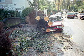
[17] The storm caused substantial damage over much of England, felling an estimated 15 million trees[18] (including six of the seven eponymous oaks in Sevenoaks,[19] historic specimens in Kew Gardens, Wakehurst Place, Nymans Garden, Hyde Park in London, and Scotney Castle[20] and most of the trees making up Chanctonbury Ring).
[26] The National Grid sustained heavy damage during the event, as crashing cables short-circuited, which in some cases overheated the main system.
The headquarters made the decision, the first one like it since before World War II: to shut down the South East power systems to maintain the network as soon as signs of overheating began.
[27] At Clayton, West Sussex, one of the village's recently restored windmills, Jill, sustained severe damage to its mechanisms and caught fire during the storm.
Météo France announced "une petite tempête en provenance des Açores" (a little storm coming in from the Azores), which reached Brittany's coast at about 18:00, later than expected.
The writer Oliver Rackham and the charity Common Ground were active in trying to prevent unnecessary destruction of trees which, although fallen, were still living.
[32][33] Some landowners, such as the National Trust, did not attempt complete clearing and replanting, realising that there was a unique opportunity to study the patterns of natural regeneration after such an event.
[35] A more positive aspect could be found among some British gardeners; as Heather Angel wrote in the Royal Horticultural Society's Journal: In some places this natural disaster has resulted in splendid vistas- views long since forgotten by some and never before seen by a whole new generation.
Because of gaps left by fallen trees, visitors to Arundel Castle, the ancestral home of the Dukes of Norfolk, can now look out over the picturesque town... At the renowned woodland rhododendron garden at Leonardslee, Sussex, the gale... opened magnificent views by removing about a thousand trees which owner Robin Loder said he would never have had the courage to thin out himself.
[37] BBC meteorologist Michael Fish drew particular criticism for reporting several hours before the storm hit: Earlier on today, apparently, a woman rang the BBC and said she heard there was a hurricane on the way; well, if you're watching, don't worry, there isn't, but having said that, actually, the weather will become very windy, but most of the strong winds, incidentally, will be down over Spain and across into France.
According to Fish, the woman in question was actually a colleague's mother who was about to go on holiday in the Caribbean, and had called regarding Hurricane Floyd to see if it would be safe to travel.
In particular, the lack of a weather ship in the Southwest Approaches, due to Met Office cutbacks,[40] meant the only manner of tracking the storm was by using satellite data, as automatic buoys had not been deployed at the time.
Ironically, earlier forecasts as far back as the preceding weekend had correctly identified that gale-force winds would affect Southern England.
Indeed, the ECMWF model forecast from 14 October 12 UTC failed to predict the strong winds and the storm position (although previous runs were closer to reality), and this could have led to inadequate warnings.
Following the storm, meteorologists at the University of Reading led by Professor Keith Browning developed the sting jet concept.
During reanalysis of the storm they identified a mesoscale flow where the most damaging winds were shown to be emanating from the evaporating tip of the hooked cloud head on the southern flank of the cyclone.
The 1968 storm, for which no warning was given, devastated agriculture and 5% of forestry in Scotland, toppled shipbuilding cranes on the Clyde, and left almost 2000 people homeless in the Central Belt.
The disruption meant the City was unable to respond to the late trading at the beginning of the Wall Street fall-out on Friday 16 October, when the Dow Jones Industrial Average recorded its greatest-ever one-day slide at the time, a fall of 108.36.