Greenbrier (Great Smoky Mountains)
Now a recreational area located within the Great Smoky Mountains National Park, Greenbrier was once home to several Appalachian communities.
Greenbrier is situated along the Middle Fork of the Little Pigeon River, stretching from Porters Flat in the south to Emert's Cove in the north, at the present park boundary.
The ridge immediately to the south connecting the two massifs, known as "the Sawteeth," consists of a series of jagged, steep cliffs, the most well-known of which spans the northern face of Charlies Bunion.
Over a dozen streams flow north from the crest of the Pinnacle, each of them cutting narrow hollows with traces of fertile bottomland.
[1] This rock type, created from ancient ocean sediments 750 million years ago, dominates the mid-level elevations in the north-central Smokies.
[2] Like the Sugarlands and Roaring Fork to the west, Greenbrier's bottomlands and streambeds are coated with sandstone, phyllite, and slate rocks of all sizes.
During the Ice Ages, the cold weather caused fracturing of the high mountain slopes, creating boulder fields.
As late as the early 20th century, residents of Greenbrier often referred to Porters Flat as "Indian Nation," which may hearken back to its days as a Cherokee settlement.
[7] The Whaleys hailed from Edgefield District, South Carolina, and crossed the Smokies at Dry Sluice Gap (near Charlies Bunion), which is just above Porters Flat.
Parton, who survived a gunshot wound to the head during the Civil War,[12] settled in the narrow flats just above the confluence of Little Bird Branch and the Middle Fork, at the western base of Greenbrier Pinnacle.
[12] Robert Parke of the University of Buffalo visited Greenbrier in the 1920s, and later wrote about his visit in his university's newspaper: We were slowly penetrating the great range within a few miles of the North Carolina border, passing cornfields so steep that we wondered how they could be cultivated, bouncing past old-time log cabins built of hand-hewn timber, and waving to unbelievably large numbers of silent children who watched amid the barking of their dogs as strangers went by.
We stopped by a cabin and inquired of an aged woman who sat leaning back in a homemade hickory chair with her feet on the rail, how far it was to Greenbriar, which had been designated to us as the end of the trail that could be traversed by four wheels.
A small force led by Confederate commander William Holland Thomas passed through Greenbrier while fleeing to North Carolina after being chased out of Gatlinburg.
[17] Shortly after the war, Greenbrier resident Perry Shults claimed to have discovered gold and silver at the headwaters of Porters Creek.
Greenbrier residents would typically trade chickens, eggs, and animal furs for clothing, salt, pepper, coal oil, and medicine.
[20] Bill Cardwell, who lived in the northern part of Greenbrier in the early 20th century, was said to have regularly sold moonshine to the sheriff of Sevier County.
[24] In the late 19th century, innovations in the logging industry, specifically the band saw, led to a rapid deforestation of the woodland along the Ohio Valley and Mississippi Delta.
Saw mills began to spring up around the Smokies, with major logging operations taking place above Elkmont and the Oconaluftee watershed.
While the residents of Greenbrier were displaced, many simply moved to the other side of the park boundary to Emert's Cove and the Webb Mountain area.
Many members of the Parton family relocated to Locust Ridge, a hilly area between Pittman Center and Richardson Cove.
This camp, which constructed most of the roads and trails in the Greenbrier area, provided valuable employment to locals during the Great Depression.
Timber rattlesnakes are not an uncommon sight on the trail, as large numbers have long been known to live on the slopes of Greenbrier Pinnacle.
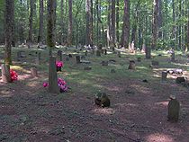
The Greenbrier area contains one of the park's largest concentrations of chimney falls and rock walls, which mark the sites of former homesteads.
In 1933, the club's members (among them park promoters David Chapman, Harvey Broome, and Carlos Campbell) met with NPS director Arno Cammerer at the Andrew Johnson Hotel in Knoxville and convinced him to grant them a special-use permit to build the cabin.
[37] The Tyson McCarter Place, located near where the Old Settlers Trail crosses Webb Creek just off U.S. Route 321, consists of a barn, corn crib, smokehouse, and springhouse constructed around 1876.
Jacob Tyson McCarter purchased the farm around 1900, and in subsequent decades he became a prominent member of the Webb Creek community.
The interior included a puncheon-log floor and a loft, and a "tater hole" (a kind of small root cellar) near the fireplace.