Eleuthera
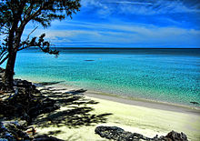
The topography of the island varies from wide rolling pink sand beaches to large outcrops of ancient coral reefs and the highest elevation point is 200 feet (61 m).
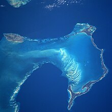
[6] Eleuthera forms part of the Great Bahama Bank on its western edge and its eastern coastline faces the Atlantic Ocean.
The topography of the island varies, including wide rolling pink sand beaches, large outcrops of ancient coral reefs, caves, and other geological features.
[8] The main island is home to a 25-acre nature preserve; the Leon Levy Native Plant Reserve, which includes an environmental education centre.
[11] An intact wooden duho or ritual seat that was made by the Taino people was found on the island of Eleuthera in the nineteenth century and is now in the collections of the British Museum.
[12] The island in its early history was known as Cigateo (or Ciguateo), meaning "distant rocky land", but this name changed following subsequent European settlement.
[11] These settlers, known as the "Eleutherian Adventurers", under Captain William Sayle gave the island its current name which derives from the feminine form of the Greek adjective ἐλεύθερος, eleutheros, meaning "free".
[14][15] The difficulties of settlement ultimately left only a few of the settlers on the island, thwarting their aim of creating the first European "democracy" in the Western Hemisphere (almost 130 years prior to the American Revolution).
[18] In early March 2019, Disney Cruise Line purchased the Lighthouse Point property on the island of Eleuthera and agreed to a development plan for the area with the Bahamian government.
[26] The largest settlements in terms of population in Eleuthera are Dunmore Town, Spanish Wells and Rock Sound.
Eleuthera is a destination for those interested in Bahamian history and nature, and neighbouring Harbour Island and Spanish Wells offer further tourism experiences.
Preacher's Cave on the north end was home to the Eleutherian Adventurers in the mid-17th century, and recent excavations have uncovered Arawak remains at the site.
[27] As of 2000, per capita GDP for the island was: $5756 Bahamian,[verification needed] with a chief human economic activity being tourism, and 6% of the population being involved in fishing, agriculture, or mining.
[31] The Haynes Public library is located in Governors Harbour in a historical building constructed in 1897; it is the oldest Government Complex on the island.
[41][44] Adjacent to the NAVFAC was the original site of the first experimental array and electronics, operated by two Western Electric engineers and a few military personnel, which continued in service as an avenue for experiments.
4 was sited at Eleuthera AAFB (ELU AUXILIARY AIR FORCE BASE), supported by contractor employees of the Radio Corporation of America (RCA) and Pan American Airways (PAA) in the 1960s and 1970s.