Grimspound
The name was first recorded by the Reverend Richard Polwhele in 1797; it was probably derived from the Anglo-Saxon god of war, Grim (more commonly known as Woden, or Odin).
In 1893 an archaeological dig was carried out by the Dartmoor Exploration Committee, which recorded many details of Grimspound as well as, controversially, making a reconstruction of the site.
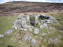
The roundhouses, with an average diameter of 3.4 metres, were each built of a double ring of granite slabs with a rubble infill, a technique still used in dry-stone walling.
He called it "The seat of judicature" for the River Dart area, and also surmised that it was "one of the principal temples of the Druids.
Other ideas about Grimspound include supposed uses as an Iron Age fort, an encampment for tin miners and even a Phoenician settlement.
Others queried its function, with Burt suggesting in 1826 that the site was a walled town and a place to keep cattle[5] A contemporary writer named Bray supported the notion of it being a ‘town’ and referenced Strabo and Caesar's descriptions of early sites as comparisons to Grimspound [6] Around the middle of the 19th century, opinions begin to change.
The valley position is noted and its function interpreted as defending cattle against wolves with the hut circles for the owners and cattle herders [7] Two men resisted this change of opinion and saw the site's use as protecting the common Dartmoor mineral of tin [8] Interestingly, another author highlighted its location on a possible ancient route through the break in the ridge of Hameldown.
This includes the pens, gateway, the central hut circles and even a large stone at the northern end of the site.
[11] The dig, one of whose members was the Reverend Sabine Baring-Gould, reconstructed some of the site, a move criticised by some of the Committee at the time and also by later researchers, including R. Hansford Worth.
On many of their excavations, charcoal and bone samples were collected for museum deposition[14] which along with their sieving of soil indicates an early observance of the importance of environmental evidence, perhaps to date the site or examine in a laboratory for microscopic finds.
[18] In 1927, Chanter firmly disagreed with the DEC, citing a lack of permanent occupation and therefore concluding that it was a defensive site to protect the tribe from cattle raiders.
Pattison and Fletcher also argued for a re-excavation of the site, and whilst they do not necessarily conclude a function or date, they do identify that it may have also had ceremonial or ritual protection for the inhabitants, rejecting the defensive theory due to the wall size being an illusion and not as substantial as they are thought to be - however, there is little evidence provided for this argument [25] Jeremy Butler, a well known author on the archaeology of Dartmoor during the 1990s, provided a description of Grimspound that for the first time recognised possible re-occupation of the site after the Bronze Age.
[26] Post 1994, there is a lack of sources on the site although many references and brief descriptions are present in hiking guides and other generic Dartmoor enthusiasts’ books.
However, these references contain contradictory statements on dating, function and generic mimicking of information from the DEC.
[30] Many also disagree over the function, interpreting it as a ‘fortress’,[29] ‘permanent settlement’,[31] 'village',[27] and ‘fortified village’[32] In 2019, Jowan Albon (as part of an undergraduate dissertation for the University of Leicester) and the Cambridge School of Mines embarked upon a geophysical survey of the site to identify new structures in the empty areas of the site and the extent of wall foundations.
The second resistance survey was more conclusive, showing four new hut circles, possible stone alignments and curvilinear features that may be paddocks or to do with later re-use of the site.
The site is enclosed by a stone wall, interrupted by a large, paved entrance facing south, uphill towards Hameldown.
[35] On the northern edge of the site is the start of the West Webburn, which was the main water source for the settlement.The walls are predominantly local granite rock as suggested by Sabine Baring-Gould in the initial Grimspound report[36] and can be seen in how Hameldown Tor weathers, providing large thick boulders suitable for facing slabs.
Twenty-four stone hut circles have been officially recorded here, although there are probably remains of more within the enclosure, which has an area of over 16,000 square metres (four acres).