Grossglockner
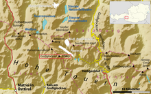
It is part of the larger Glockner Group of the Hohe Tauern range, situated along the main ridge of the Central Eastern Alps and the Alpine divide.
The characteristic pyramid-shaped peak actually consists of two pinnacles, the Großglockner and the Kleinglockner (3,770 m or 12,370 ft, from German: groß 'big', klein 'small'), separated by the Glocknerscharte col.
The denotation Glogger is mentioned in a 1583 description of the Tyrolean Kals legal district, then referring to the whole ridge south of the Alpine main chain.
Its view over more than 150,000 km2 (58,000 sq mi) of the Earth's surface reaches as far as the Upper Swabian Plateau in the northwest, to Regensburg and the peaks of the Bohemian Forest in the north, to Ortler in the west, to the Padan Plain in the south, and to Triglav and the Totes Gebirge range in the east.
They engaged two peasants from Heiligenblut as mountain guides to do the first explorations for an ascent through the Leitertal valley, which is the side of Grossglockner with the least ice (people feared glaciers in these times).
They suffered with bad weather and a first effort failed, but on 25 August 1799 Hohenwart and at least four other people, including the two "Glockners", reached—again—the Kleinglockner, where they installed one of the first summit crosses (one of the main goals of the church expedition).
Four peasants and carpenters (the "Glockners" and two others who are not known) did a track in the snow, had installed fixed ropes at some steeper sections up to the end of the Glocknerleitl, and even built a second refuge, called Hohenwarte Hut.
A local peasant named Sepp Hoysen is documented as a member of the second Grossglockner expedition in 1802, and the surveyor Ulrich Schiegg mentioned one Martin Reicher as "Glockner" guide.
Therefore, the people of Kals tried to lay out a straight ascent from the western side, which however was not reached until Julius von Payer explored the ridge between Glöcknerleitl and Ködnitzkees in 1863.
[7] In 1876 Count Pallavicini and his guide Hans Tribusser undertook the first expedition up the steep glaciated Northeast Face, chopping 2,500 steps into the Pallavicinirinne in an ice climbing master stroke not repeated for 23 years.
In 1879 Count Pallavicini dedicated a new iron summit cross on the occasion of the silver wedding of Emperor Franz Joseph of Austria and Empress Elisabeth; both had visited Heiligenblut and walked to the present-day Franz-Josefs-Höhe viewpoint in 1865.
The Grossglockner became Austria's highest mountain, when the South Tyrolean Ortler region had to be ceded to the Kingdom of Italy according to the 1919 Treaty of Saint-Germain, which promoted its reputation as a tourist attraction.
Mass tourism was decisively promoted by the scenic High Alpine Road (Großglockner-Hochalpenstraße) running from Heiligenblut to Bruck in Salzburg with a branch-off to the Franz-Josefs-Höhe viewpoint.
The pass road, Austria's highest, reaches 2,576 m (8,451 ft), and is one of the most popular tourist attractions in the country (second after Schönbrunn Palace) with about 270,000 vehicles and 900,000 visitors every year, about 50 million since its opening.