Guadalupe Mountains
[4] The first Europeans to arrive in the area were the Spaniards in the 16th century, but they did not make serious attempts to settle in the Guadalupe Mountains.
The Butterfield Overland Mail traveled over Guadalupe Pass located at 5,534 ft (1,687 m) above sea level.
A cavalry was known as the Buffalo Soldiers was ordered to the area to stop Indian raids on settlements and mail stage routes.
Wallace Pratt donated about 6,000 acres (24 km2) of McKittrick Canyon which became part of Guadalupe Mountains National Park.
In 1978, the United States Congress designated 46,850 acres (190 km2) of the Texan side of the range as a wilderness area, managed by the National Park Service.
[1] The northeastern extension ends about 10 miles (16 km) southwest of Carlsbad, near White's City and Carlsbad Caverns National Park; the southwest tip ends with El Capitan about 90 miles (140 km) east of El Paso.
The northwestern extension, bounded by a dramatic escarpment known as "The Rim", extends much further into New Mexico, to near the Sacramento Mountains.
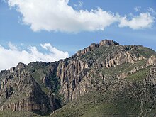
Much of the range is built from the ancient Capitán Reef that formed at the margins of a shallow sea during the Permian period.
Buried organic matter formed oil and natural gas resources, and ~250,000 wells have been drilled in the surrounding region.
[10] Lateral extension of the Colorado Plateau occurred as a result, forming topographic relief and mountainous features along crustal extension features in the Basin and Range province, such as the Rio Grande rift west of the Guadalupe Mountains.
A mechanism similar to extension in the Rio Grande rift is thought to have generated topographic relief in the Guadalupe Mountains, and the timing of topographic relief generation has been estimated to ~20 million years ago using cave speleothem records and interpreted to reflect drainage of subsurface aquifers as topographic relief was generated along the margin of the mountain range.
[11] The Guadalupe Mountains are mainly carved by a series of NW-SE trending canyons leading to exposure of marine rocks at their current elevation.
In the dry, semi-arid environment, continuous limestone bedrock of the Capitan Reef forms large prominent cliffs traceable across the landscape.
Groundwater circulating through deep fractures dissolves limestone and forms extensive cave networks, including the Carlsbad Caverns.
The history of the range includes occupation by ancient Pueblo and Mogollon peoples, and by the Apache and various Anglo outlaws in the 19th century.