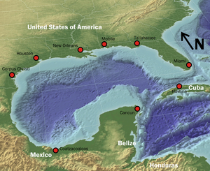
Gulf Coastal Plain
[1] It continues along the Gulf in northeastern and eastern Mexico, through Tamaulipas and Veracruz to Tabasco and the Yucatán Peninsula on the Bay of Campeche.
The inner part, initially a plain, has been maturely dissected into an elaborate complex of hills and valleys, usually of increasing altitude and relief as one passes inland.
The southern part of the state includes the Everglades, a large area of low, flat, marshy land, overgrown with tall reedy grass.
The eastern coast is fringed by long-stretching sand reefs, enclosing lagoons so narrow and continuous that they are popularly called rivers.
They appear to be due to the forward growth of corals and other lime-secreting organisms towards the strong current of the Gulf Stream from which they obtain their food.
Its inner border affords admirable examples of topographical discordance where it sweeps northwestward square across the trend of the piedmont belt, the ridges and valleys, and the plateau of the Appalachians.
The hilly belt or dissected escarpment determined by the Grand Gulf formation in western Mississippi is the most distinct.
The small proportion of total water volume supplied from the great Missouri River basin is due to the light precipitation in that region.
The river has eroded a valley about 40 to 50 miles (64 to 80 km) wide enclosed by bluffs one or two hundred feet high in the northern part.
On account of the rapid deposition of sediment near the main channel at times of overflow, the flood plain, as is normally the case on mature valley floors, has a lateral slope of as much as 5, 10, or even 12 ft (3.7 m) in the first mile from the river, but this soon decreases to a less amount.
Any chance irregularity is exaggerated, and in time a series of large serpentines or meanders is developed, the most-symmetrical examples at present being those near Greenville, Mississippi.
A belted arrangement of reliefs and soils, resulting from differential erosion on strata of unlike composition and resistance, characterizes almost the entire area of the coastal plain.
This dips gently seaward with its scalloped inland-facing escarpment overlooking a denuded central prairie region of irregular structure and form.
Its gently undulating or rolling seaward slope of 2 or 3 ft per mile (500 mm/km), covered with marly strata and rich black soil, determines an important cotton district.
Then comes the East Texas timber belt, broad in the northeast, narrowing to a point before reaching the Rio Grande, a low and thoroughly dissected escarpment of sandy Eocene strata.
The plateau terminates in a maturely dissected fault scarp approximately 300 or 400 feet (120 m) in height as the northern boundary of the Rio Grande embayment.
In front of the Brazos and the Colorado, the largest of the Texan rivers, the coast-line is very gently bowed forward as if by delta growth.
Nearly all the rest of the coast is fringed by off-shore reefs or barrier islands, built up by waves from the very shallow sea bottom.
The northern region uplands are dominated by pine, originally longleaf and slash in the south and shortleaf mixed with hardwoods in the north.
The southern region has tropical and subtropical moist broadleaf forests and western Gulf coastal grasslands.
[6] A global satellite study by German and USA scientists spanning the last decade indicates groundwater resources are shrinking due to overuse causing regional water security uncertainty in a changing climate.
Surface water quality is declining due to increasing population, depleted streams, and land subsidence along certain coastlines.