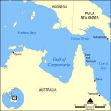
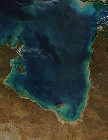
Gulf of Carpentaria
[3] The Gulf and adjacent Sahul Shelf were dry land at the peak of the last ice age 18,000 years ago when global sea level was around 120 m (390 ft) below its present position.
[5] Yulluna (also known as Yalarnga, Yalarrnga, Jalanga, Jalannga, Wonganja, Gunggalida, Jokula) is an Australian Aboriginal language.
The Kayardild language region includes the landscape within the local government boundaries of the Mornington Shire Council.
[7] The first European explorer to visit the region (and Australia) was the Dutch Willem Janszoon (whose name is also written as Jansz) in his 1605–06 voyage.
His fellow countryman, Jan Carstenszoon (or Carstensz), visited in 1623 and named the gulf in honour of Pieter de Carpentier, at that time the Governor-General of the Dutch East Indies.
To the east is the Top End of the Northern Territory, including the Cape York Peninsula, and the Torres Strait which joins the Gulf to the Coral Sea.
The Great Dividing Range, which parallels the entire east and south-east coast, is responsible for the typical pattern of a well-watered coastal strip, a fairly narrow band of mountains, and then a vast, inward-draining plain that receives little rainfall.
In the Gulf Country, however, there are no mountains to restrict rainfall to the coastal band and the transition from the profuse tropical growth of the seaside areas to the arid scrubs of central Australia is gradual.
[10] The patch reefs have their upper surfaces at a mean water depth of 28.6 ± 0.5 m (94 ± 1.5 ft), were undetected by satellites or aerial photographs, and were only recognised using multibeam swath sonar surveys supplemented with seabed sampling and video.
Their existence points to an earlier, late Quaternary phase of framework reef growth under cooler-climate and lower sea level conditions than today.
[12] By 2011, the numbers of illegal fishing boat interceptions had declined significantly with the cause attributed to enforcement efforts and education programs in Indonesia.