Halaib Triangle
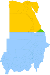
The Halaib Triangle is an area of land measuring 20,580 square kilometres (7,950 sq mi) located on the Northeast African coast of the Red Sea.
The area, which takes its name from the town of Halaib, is created by the difference in the Egypt–Sudan border between the "political boundary" set in 1899 by the Anglo-Egyptian Condominium, which runs along the 22nd parallel north, and the "administrative boundary" set by the British in 1902,[1] which gave administrative responsibility for an area of land north of the line to Sudan, which was an Anglo-Egyptian client at the time.
In 1994, the Egyptian military moved to take control of the area as a part of Red Sea Governorate, and Egypt has been actively investing in it since then.
Although both countries continued to lay claim to the land, joint control of the area remained in effect until 1992, when Egypt objected to Sudan's granting of exploration rights for the waters off the Triangle to a Canadian oil company.
In January 1995, Egypt rejected a Sudanese request for the OAU Foreign Ministers' Council to review the dispute at their meeting in Addis Ababa.
[13] Then, after an unsuccessful assassination attempt on Egyptian President Hosni Mubarak when he arrived in Addis Ababa to attend the meeting, Egypt accused Sudan of complicity, and, among other responses, strengthened its control of the Halaib Triangle, expelling Sudanese police and other officials.
[5][13] In 1998, relations between Egypt and Sudan somewhat improved, and the countries announced their intention to work together to resolve the Halaib Triangle dispute, with increased cooperation between their security forces.
[13] During a visit to Egypt by Sudanese President Omar al-Bashir in December 1999, a joint communique was issued pledging to solve the Halaib dispute "in an integrational brotherly context..."[5] In January 2000, Sudan withdrew its forces from the area, effectively ceding control of the border zone to Egypt, whose forces have occupied and administered the area since.
[14] In 2004, Sudanese president Omar Al-Bashir claimed that despite his nation's withdrawal in 2000, and Egypt's de facto control of the Triangle, the area still rightfully belonged to Sudan, which had "never relinquished" it.
"[16] The Eastern Front, a Sudanese politico-military coalition comprising the Beja Congress and Free Lions that signed a peace agreement with Khartoum, has stated that it considers Halaib to be part of Sudan due to its population being ethnically, linguistically and tribally connected to that country.
Voter registration did not take place in the Halaib Triangle area because the team from the Sudanese election commission was refused entry by Egyptian authorities.
[citation needed] It was reported in the Sudanese daily Al-Ahram Today on 22 April 2010 that Al-Taher Muhammad Hasaay, the former head of the Halaib Council and a member of the Bisharin tribe who was campaigning against the Egyptian military presence in the Halaib Triangle, died in a hospital in Cairo after having been detained by Egyptian security forces without trial for two years.
The letter was written on behalf of the Bisharin, Hamad-Orab and Aliyaab tribes and complained of the forced inclusion of 20 villages that had been administered under indigenous civil society structures into two Egyptian electoral districts.
[3] A new asphalt-paved road has been built which begins south-west of Alshalateen and goes through the western portion of the triangle to the border pass of Suhin (Sohin), which is located at the 22nd parallel.
The mountainous area of Gebel Elba is a nature reserve declared by Egypt in a decree signed by the former prime minister Ahmed Nazif.