Ham Wall
Since the last Ice Age, decomposing plants in the marshes of the Brue valley in Somerset have accumulated as deep layers of peat that were commercially exploited on a large scale in the twentieth century.
Consumer demand eventually declined, and in 1994 the landowners, Fisons, gave their old workings to what is now Natural England, who passed the management of the 260 hectares (640 acres) Ham Wall section to the RSPB.
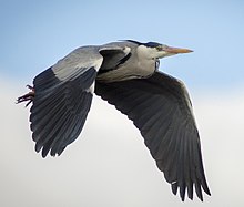
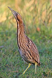
The Ham Wall reserve was constructed originally to provide reed bed habitat for the Eurasian bittern, which at the time was at a very low population level in the UK.
There are important breeding populations of wetland birds including the rare little bittern and great white egret, and the area hosts several other uncommon animals and plants.
Potential future threats may result from increasing unpredictability in the UK climate, leading to heavy summer rains and extensive flooding.
[1] By around 6,500 to 6,000 years ago the marshes had become reed beds interspersed with rhynes (ditches) and open water, and parts of the area were in turn colonised by wet woodland.
[4] The formation of the bog was aided by the Somerset Levels' large water catchment area, high rainfall in the Mendips and Blackdown Hills and raised marine clay deposits which restricted drainage to the sea;[5] the same impermeable material underlies the peat, which in places is up to 7.3 metres (24 ft) thick.
[8] Much of the landscape was owned by the church in the Middle Ages when substantial areas were drained and the rivers diverted, but the raised bogs remained largely intact.
Only the Inclosure Acts of the 18th century, mostly between 1774 and 1797, led to significant draining of the peat bogs, although the River Brue still regularly flooded the reclaimed land in winter.
[18] The main access to the reserve on leaving the car park is the Ham Wall loop; this follows the north bank of the canal, crosses at a bridge and returns via a parallel grass track, 2.7 kilometres (1.7 mi) in total.
Two machines are used, an amphibious Truxor tracked reed cutter to harvest wetter areas, and a faster Softrak for islands and where water levels have been lowered.
[4] Joint schemes include reed bed management across the area,[23] improved pedestrian and cycle access,[24] and the provision of visitor facilities at Ashcott corner between the Ham Wall and Shapwick Heath reserves.
A winter evening roost of common starlings is one of the largest in the UK, and attracts visitors to see hundreds of thousands, sometimes millions, of these birds assemble before descending into the reed bed.
[4] Rare visitors to the reserve in recent years include a collared pratincole and a whiskered tern in 2016,[27] a singing male pied-billed grebe and a squacco heron in 2013,[28] and a blue-winged teal in 2012.
[33] Greater unpredictability in the UK climate may lead to heavy summer rains which would adversely affect ground-nesting birds, invertebrates and other wildlife.
[34] Despite Environment Agency planning, recent significant river flooding events occurred on the Levels in November 2012[37] and following Cyclone Dirk in winter 2013–2014,[38] the latter leaving 6,900 hectares (17,000 acres) of agricultural land under water for over a month.
[39] Water-based sports and recreation elsewhere in the Levels could possibly enable non-native species to invade the wetlands, and the number of visitors to the area can cause congestion on local roads, particularly those coming for the winter evening starling roost.
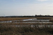

Reedbed and ditches
Hides and viewpoints
Visitor centre and toilet block
Woodland Footpaths