Altstadt, Hamburg
Altstadt (German: [ˈalt.ʃtat] ⓘ, literally: "Old town"), more precisely Hamburg-Altstadt – as not to be mistaken with Hamburg-Altona-Altstadt – is one of the inner-city districts of the Free and Hanseatic City of Hamburg, Germany.
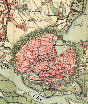
An Ingaevonian settlement at this location was known by the name "Treva" – a strategic trading node on amber routes during Iron Age and Late Antiquity.
In the 8th century CE, Saxon merchants established what was to become the nucleus of Hamburg: the "Hammaburg", then a refuge fort located at today's Domplatz, the site of the former cathedral.
Today, Altstadt is bordered by Alster (i.e. Alsterfleet and Binnenalster) to the West and North-West, the rail tracks of Hamburg-Altona link line and Hauptbahnhof to the East, and Zollkanal to the South.
Hamburg-Altstadt has four designated quarters (German: Viertel, or specifically used in Hamburg: Quartier) for statistical and planning purposes, however not recognized as administrative subdivisions.