Hamilton, New Zealand
Education and research and development play an important part in Hamilton's economy, as the city is home to approximately 40,000 tertiary students and 1,000 PhD-qualified scientists.
[8] The settlement was named by Colonel William Moule after Captain John Fane Charles Hamilton,[9] the commander of HMS Esk, who was killed in the battle of Gate Pā, Tauranga.
Local Māori were the target of raids by Ngāpuhi during the Musket Wars,[16] and several pā sites from this period can still be found beside the Waikato River.
The Hamilton City Council is building a 2/4-lane arterial road, Wairere Drive, through the northern and eastern suburbs to form a 25 km suburban ring road with State Highway 1, which is due for completion in early 2015,[46] while the New Zealand Transport Agency plans to complete the Hamilton section of the Waikato Expressway by 2019, easing congestion taking State Highway 1 out of the city and bypassing it to the east.
and was further modified by the 181 CE Hatepe eruption, when again Lake Taupō level fell 34 m (112 ft), generating a 20 km3 (4.8 cu mi) flood, equivalent to 5 years' normal flow in just a few weeks.
[citation needed] In its natural state, Hamilton and environs was very swampy in winter with 30 small lakes connected to surrounding peatlands.
Hamilton was surrounded by 7 large peat bogs such as Komakorau to the North and Rukuhia and Moanatuatua to the South, as well as many smaller ones all of which have now been drained with only small remnants remaining.
This swampy, damp environment was at the time thought to be an ideal breeding ground for the TB bacillus, which was a major health hazard in the pioneering days.
One of the reasons why population growth was so slow in Hamilton until the 1920s was the great difficulty in bridging the many arms of the deep swampy gullies that cross the city.
With higher rainfall and drainage from the extensive peat land to the west, the water level rose so the narrow peninsula was drowned so forming one larger lake.
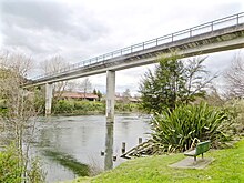
Lake Rotoroa offers a diverse range of recreational activities, including walking trails, picnic areas, and water sports, making it a popular destination for both locals and tourists.
These trails offer stunning views of the lake and surrounding landscapes, providing a tranquil setting for exercise enthusiasts and nature lovers alike.
[58] Hamilton also features very high humidity (similar to tropical climates such as Singapore) which can make temperatures feel much higher or lower than they are.
[60] Hamilton also has the lowest average wind speed of New Zealand's main centres as a result of its inland location, in a depression surrounded by high hills and mountains.
After Farmers Hamilton moves from its existing site on corner of Alexandra and Collingwood streets into the redeveloped Centre Place in late 2013,[99] each major mall will have the department store as an anchor tenant.
In 2004, Hamilton City Council honoured former resident Richard O'Brien with a life-size bronze statue of him as character Riff Raff, of The Rocky Horror Picture Show, in his space suit.
Te Awa, an enclosed speciality retail mall at The Base, was awarded a silver medal by the International Council of Shopping Centres for the second-best expansion in the Asia Pacific region.
Just 20 minutes' drive away is Ngāruawāhia, the location of Turangawaewae Marae and the home of Māori Queen Nga Wai Hono i te Po.
[119] The New Zealand Household Travel Survey 2015 – 2018 said that 86% of Hamilton trip legs were made by car (60% as driver, 26% as passenger), 10% were walking, 2% cycling and 1% by bus.
The airport is the base for pilot training schools and the aircraft manufacturer, Pacific Aerospace, is located at the northern end of the runway.
[126] A $6.7m, 2.7 km (1.7 mi) Western Rail Trail opened in 2017 linking Glenview, Melville, and Deanwell, Hamilton Girls’ High School, Wintec and the city centre.
[152] It was then extended from Hukanui Rd to Crosby Rd in 2010, to Ruakura Rd in 2013[136] and 5.5 km (3.4 mi) to Cambridge Rd in 2014,[153] when the Pukete Rd to Resolution Dr section was widened from 2 to 4 lanes,[136] and roundabouts replaced with traffic lights, at a cost of $84m.
Hamilton City Council removed funding from its 2024-2034 Long Term Plan to widen many sections of the road, which included the construction of new bus priority and transit lanes.
[161] The plan for the area says, "it is intended that the arterial routes also make provision for alternative modes of transport such as light rail by maintaining corridors.
When it finally closed in the 1990s it was very dilapidated, but NZHPT supported restoration of the Category 1 historic place, retaining original windows, big sliding doors and the saw-tooth roof.
Restrictions are still placed on garden sprinklers in summer and the Pukete sewage works was still not always meeting discharge Resource consent conditions in 2013.
Initially sections were large enough for septic tanks to work as well as they could in peatlands, but it wasn't long before the 1882 drainage scheme[210] was used for sewage connections.
By 1904 complaints were being made about the blocked insanitary drain between Victoria and Anglesea Streets, resulting in a faltering start on a night soil service.
It now cleans 40 million litres (11,000,000 US gal)/day, which is aerated for about 2 hours in a sedimentation tank, disinfected with chlorine, dechlorinated with sulphur dioxide and discharged into the Waikato through a diffuser outfall on the river bed.
In 1919 it was bought by the government and, by 1921, an 11 kV AC line linked it to Hamilton.,[234] allowing the "noisy, smoky", Kent St power station to close in July 1922,[236] by which time it was rated at 170 kW.