Harney Basin
One of the least populated areas of the contiguous United States, it is located largely in northern Harney County, bounded on the north and east by the Columbia Plateau—within which it is contained, physiographically speaking—and on the south and west by a volcanic plain.
[4] No streams cross the volcanic plains that separate the basin from the watershed of the Klamath River to the southwest.
Dryland ranching is the basis of the area's economy, with relatively little irrigation water available from the streams that enter Malheur Lake.
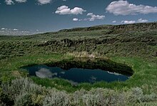
"Alkali Field is located directly south of Malheur Lake, a few kilometers east of the Donner und Blitzen River.
Pollen records indicate that the climate, especially the level of rain and snowfall, has varied greatly since the end of the Pleistocene.
A total of 23 people died while the party wandered in the basin until finding water at the Crooked River.
Growing settlement pressures, in particular the discovery of gold in the surrounding mountains, as well as the interest of white settlers to form ranches in the region, caused the Commissioner of Indian Affairs to abruptly terminate the reservation in 1879.
The basin has a widespread decline in groundwater which has put the region at risk of ecological and economic collapse.