Tasman Glacier
[1][3][4] It is as much as 4 kilometres (2.5 mi) wide and 600 metres (2,000 ft) thick, and lies entirely within the borders of Aoraki / Mount Cook National Park.
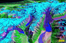
The glacier covers an area of 101 square kilometres (39 sq mi) and starts at a height of 3,000 metres (9,800 ft) above sea level.
The glacier remained at a constant 28 km (17 mi) in length for all of its recorded history in the 20th century before starting its current period of rapid melting in the 1990s.
[16]: 28–29 Similarly, Tasman Glacier's significant ice loss over the past decades has impacted tourism,[16]: 1 with an increasing number of crevasses being exposed and not filled in by snow any more, requiring guided tours to avoid these areas, and restricting the heli skiing season to July, August and September.
Boats are not allowed closer than 1.5 km (0.9 mi) to the 50 m (160 ft) tall terminal face of Tasman Glacier for safety reasons.
At that point, the rock-covered lower Tasman Glacier in the valley between the moraine walls is 2.5 km (1.6 mi) wide.