Herman Moll
Between 1691 and 1710 his business was located at the corner of Spring Gardens and Charing Cross, and he finally moved along the River Thames to the Strand where he remained until his death.
With its depiction of the processing of freshly caught cod for shipment to Europe, Moll highlighted for subscribers and viewers the importance of this sector for his native England.
[10] Pritchard argues that the Beaver Map was "one of the first and most important cartographic documents relating to the ongoing dispute between France and Great Britain over boundaries separating their respective American colonies ...
One of Moll's maps of the island of Newfoundland, published in the 1680s, showed Pointe Riche, the southern limit of the French Shore, to be situated at 47°40' North latitude.
In 1763 the French attempted to use this map to establish their claim to the west coast of Newfoundland and Labrador, arguing that Point Riche and Cape Ray were the same headland.
Governor Hugh Palliser and Captain James Cook found evidence to refute Moll's claim, and in 1764 the French accepted the placement of Pointe Riche near Port au Choix.
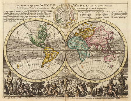
However, all political considerations aside, Moll's maps were in his lifetime and after probably quite popular given the high number that survive, and are still among the most sought-after aesthetic engravings in the history of cartography.
[13] Moll's road maps of England and Scotland, at first published on their own, were added to editions of Daniel Defoe's A Tour Thro' the Whole Island of Great Britain.
This confirmed me in the opinion I have long entertained, that the maps and charts place this country at least three degrees more to the east than it really is; which I thought I communicated many years ago to my worthy friend, Mr. Herman Moll, and gave him my reasons for it, Although he has rather chosen to follow other authors."