Higashitagawa District, Yamagata
As of October 2013, the district has an estimated population of 29,957 and an area of 282.47 km2.
Tagawa County was an ancient place name in part of Dewa Province.
Under the Tokugawa shogunate, much of the area of both districts were ruled as part of Tsuruoka Domain.
With the establishment of the municipality system on April 1, 1889, the district was consolidated into 26 villages.
On February 1, 1955, the villages of Izumi, Hirose and Toge merged to form the town of Haguro.
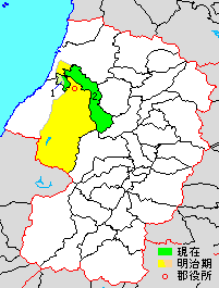
yellow & green area=original extent in Meiji period; green=present area. 1=Mikawa, 2=Shōnai

- Ōizumi
- Hongō
- Yamazoe
- Kogane
- Itsuki
- Azuma
- Kurokawa
- Hirose
- Izumi
- Watamae
- Yokoyama
- Oshikiri
- Naganuma
- Yaejima
- Fujishima
- Tōei
- Toge
- Tachiyazawa
- Karikawa
- Izaai
- Yamato
- Shōman
- Amarume
- Niibori
- Sakae
- Hirono
Purple=Tsuruoka City
Pink=Sakata City
Red=Shōnai Town
Orange=Mikawa Town