Mogami District, Yamagata
As of August 2013, the district has an estimated population of 42,788 and an area of 1,508.54 km2.
All of the city of Shinjō was formerly part of Mogami District.
Mogami County was an ancient place name in part of Dewa Province; however, it was located to the south of the present Mogami District, in an area corresponding roughly to modern Higashimurayama District and parts of Nishimurayama District.
Under the Tokugawa shogunate, much of the area of modern Mogami District was ruled as part of Shinjō Domain.
The area was organized as modern Mogami District in 1878.
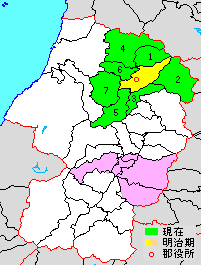
yellow & green - original extent in Meiji period
green - present area
pink - location in pre-Meiji period.
- Kaneyama
- Mogami
- Funagata
- Mamurogawa
- Ōkura
- Sakegawa
- Tozawa

Purple - Shinjō-shi
- Shinjō
- Inafune
- Yamuki
- Hagino
- Nishi-Oguni
- Higashi-Oguni
- Mamurogawa
- Araki
- Nozoki
- Sakegawa
- Toyosato
- Furukuchi
- Tozawa
- Funagata
- Ōkura
- Kaneyama