List of highways in Niagara County, New York
The state roads are supplemented by 283.2 miles (455.8 km) of county-maintained highways, which carry unsigned county route designations.
Within the city, US 62 connects to NY 265 and I-190 before splitting into two one-way streets on the east side of downtown.
US 62 follows the one-way couplet along Walnut and Ferry avenues (north and southbound, respectively) to its end at NY 104 near the Rainbow Bridge.
It follows Pine Avenue from NY 104 just north of downtown to the east end of US 62's one-way couplet.
The route intersects NY 78 on the edge of the Erie Canal in downtown Lockport before continuing east out of the city.
Within Niagara County, the route travels northwesterly across rural areas of Royalton to its north end at NY 31 east of the city of Lockport.
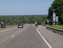
North of downtown, the highway follows Lake Avenue northeast from Lockport through some rolling countryside.
Commercial development returns about 3.5 miles (5.6 km) north of Lockport at Wright Corners, where the highway has a brief concurrency with NY 104.
The route follows Lockport Street east from the junction, connecting to the Niagara Scenic Parkway at the eastern village line before proceeding in an east-southeast direction across the towns of Porter and Wilson.
It continues on this track to Cambria, where the route turns eastward to run concurrent with NY 104 for 2 miles (3.2 km) to the Lockport town line.
It heads southeast and south across the southwest corner of the city along the bypass to its end at Robinson Road.
After becoming Akron Road, the route generally southeastward towards Tonawanda Creek and the Erie County line.
Continuing on, the highway has a junction with nearby NY 265 before descending the Niagara Escarpment toward the village of Lewiston.
As NY 265 heads northwest, it makes its way to the reservoir at the Niagara Power Project in the town of Lewiston, which it crosses while running alongside I-190.
Shortly thereafter, access to I-190 and Canada is provided through Upper Mountain Road, which serves the last exit before the Lewiston–Queenston Bridge and the Canadian border.
The concurrency ends after 6 miles (9.7 km), with NY 384 continuing along the riverside to provide the southernmost Niagara County exit for I-190.
After just one block, NY 384 turns north onto John B. Daly Boulevard at an intersection with the southern segment of the Niagara Scenic Parkway.
The divided highway ends at Wheatfield Street, where NY 425 forks to the northeast and becomes the two-lane Erie Avenue.
Once NY 425 reaches US 62 on the outskirts of the city, it assumes the name Shawnee Road and resumes a northerly course across the county.
It follows a due north course while on Ward Road, crossing US 62 in Wheatfield and meeting NY 31 in Sanborn as Buffalo Street.
From here, NY 429 follows the Lewiston–Cambria town line to Pekin, where it reaches the edge of the Niagara Escarpment at Upper Mountain Road (CR 5).
The LaSalle Expressway is a short east–west highway located in the southeastern part of the city of Niagara Falls.
The expressway has three exits along its length that serve the Niagara Scenic Parkway, 77th Street, and NY 384.
Its reference route designation is NY 951A, a number used by two separate highways in the Niagara Falls area.
Both highways are owned by the New York State Office of Parks, Recreation and Historic Preservation but maintained by NYSDOT.
A handful of routes once entered Niagara County, but no longer do as a result of realignments, truncations, or other changes to the state highway system.
The shift was part of a larger change in NY 3's alignment that moved the west end of the route to Sterling in Central New York.
The Seaway Trail is a 518-mile (834 km) National Scenic Byway that runs across New York and Pennsylvania, following a series of roads and highways that travel along Lake Erie, the Niagara River, Lake Ontario, and the Saint Lawrence Seaway.
[26] The trail forms a loop through Niagara County, serving as a scenic byway and connecting various points of interest.
[27] The Niagara Wine Trail follows Lake Ontario and links Wilson Harbor and Amherst.