Historic Columbia River Highway
The original highway was promoted by lawyer and entrepreneur Sam Hill and engineer Samuel C. Lancaster, to be modeled after the great scenic roads of Europe.
From the very beginning, the roadway was envisioned not just as means of traveling by the then popular Model T, but designed with an elegance that took full advantage of all the natural beauty along the route.
Since then, modern Interstate 84 has been built parallel to the highway between Portland and The Dalles, replacing it as the main travel route and resulting in the loss of some of the original sections of road.
At Shellrock Mountain to the east, long believed to be an impassable barrier, Governor Oswald West used prison labor in 1912 to prove that it was possible to build a road, at least temporarily.
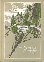
Hill was especially impressed by Switzerland's Axenstrasse, a road built along Lake Lucerne in 1865 that included a windowed tunnel, and wanted to build a similar scenic highway through the Columbia River Gorge.
[8] In laying out the highway, Lancaster sought not only to create a transportation artery, but to make the gorge's "beautiful waterfalls, canyons, cliffs and mountain domes" accessible to "men from all climes".
For five months, from September 1913 to January 1914, he laid out a route for about 21 miles (34 km) to the Hood River County line west of Cascade Locks.
Eleven larger reinforced concrete bridges and several full or half viaducts were specially designed for the Multnomah County portion of the highway, taking the road over streams or along steep hillsides with a minimum of earthmoving.
With the completion of the Oneonta Tunnel and a number of bridges, the road was open to traffic west of Warrendale, near Horsetail Falls, by October 1914.
An old wooden Pratt through truss bridge over the Sandy collapsed on April 25, 1914, and its steel replacement was built as part of the Columbia River Highway project.
The most difficult location was at Mitchell Point, where the old road included grades of up to 23% to take it over a saddle, and the railroad occupied the only available land between the cliff and the river.
Elliott solved the problem by building the Mitchell Point Tunnel—a windowed tunnel like on Switzerland's Axenstrasse—through the cliff, with a viaduct on the west approach.
To dedicate the completed highway between Portland and Hood River, two ceremonies were held at Multnomah Falls and Crown Point on the same day in June 1916.
Near the east end, the Mosier Twin Tunnels, completed in 1920, carried the road through a portion of the hill; the eastern of the two included two windows, similar to the five at Mitchell Point.
[19] Because of its beauty, photographers like William Henry Jackson, Benjamin A. Gifford, Arthur Prentiss and Carleton Watkins documented the construction of this highway.
A completion ceremony for the Columbia River Highway was held on June 27, 1922, when Simon Benson symbolically helped pave the final portion near Rowena.
[24][25] Even as construction was ongoing on the east end of the Columbia River Highway, the design had become obsolete, as motorists wanting to get to their destination greatly outnumbered tourists taking a pleasure drive.
The highway's new two-lane alignment, completed in 1937, crossed the old road several times between the community of Bonneville (just east of Tanner Creek) and Cascade Locks.
[31] Starting in June 2006, the Oregon Department of Transportation, using about $1.5 million in state and federal money, began restoring the Oneonta Tunnel to its 1920s appearance.
Forty miles of the route are open to motor vehicles: The remaining portions of the HCRH designated for non-motorized use are now known as the Historic Columbia River Highway State Trail.
Currently, cyclists wishing to travel between these two towns must ride on the shoulders of I-84 for much of the distance, or the much more dangerous and narrow State Route 14 on the Washington side of the river.