History of East Africa
[1] In 78,300 BP, amid the Middle Stone Age, a two and half to three year old human child was buried at Panga ya Saidi, in Kenya.
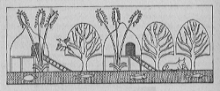
[5] In the uplands of Nakfa, there is painted rock art (e.g., petroglyphs) in Karora depicting symbolic representations, men, and animals (e.g., horses, camels, antelopes, goats, sheep, cattle), which has been dated to the 2nd millennium BCE.
There is also evidence that carbon steel was made in Western Tanzania by the ancestors of the Haya people as early as 2,300 to 2,000 years ago (about 300 BC or soon after) by a complex process of "pre-heating" allowing temperatures inside a furnace to reach 1300 to 1400 °C.
[18] Though some may have been created later, the earlier red finger-painted rock art may have been created between 6000 BP and 1800 BP, to the south of Kei River and Orange River by Khoisan hunter-gatherer-herders, in Malawi and Zambia by considerably dark-skinned, occasionally bearded, bow-and-arrow-wielding Akafula hunter-gatherers who resided in Malawi until the 19th century CE, and in Transvaal by the Vhangona people.
[19] Bantu-speaking farmers, or their Proto-Bantu progenitors, created the later white finger-painted rock art in some areas of Tanzania, Malawi, Angola, Zambia, and Zimbabwe, as well as in the northern regions of Mozambique, Botswana, and Transvaal.
[19] The Transvaal (e.g., Soutpansberg, Waterberg) rock art was specifically created by Sotho-speakers (e.g., Birwa, Koni, Tlokwa) and Venda people.
[20] The city-state of Kerma emerged as the dominant political force, controlling the Nile Valley between the first and fourth cataracts, an area as large as Egypt.
[22] The earliest recorded ancient Egyptian expedition to Punt was organized by Pharaoh Sahure of the Fifth Dynasty (25th century BCE), returning with cargoes of antyue and Puntites.
[30][a][31] In the pre-Swahili period, the region was occupied by smaller societies whose main socioeconomic activities were pastoralism, fishing, and mixed farming.
Archeological data has revealed the use of Kwale and Urewe ceramics both along the coast and within the interior parts, showing that the regions had a shared lifeway in the Late Stone and Early Iron Ages.
[40] The beginning of a conversion process of the Kingdom of Axum to Christianity is thought to have occurred with the arrival of two Syrian brothers Frumentius and Aedesius, sometime in the reign of Ezana.
[41] The conversion, bringing with it Hebraizing elements, was partial, initially was limited to the court and probably affected only the caravan trading route areas between Axum and Adulis.
[43] A strong possibility exists that the Christian Kaleb of Axum, who had dispatched military contingents to fight against the Judaizing Dhu Nuwas of the Arabian peninsula kingdom of Himyar banished opponents to the Simien Mountains, which later emerged as a Beta Israel stronghold.
Legends surrounding a Jewish queen called Judith (Gudit) have been dismissed by Ethiopian specialists like Edward Ullendorff as without foundation in any historical facts.
[40] The Tunni, composed of five sub-clans (Da'farad, Dakhtira, Goygali, Hajuwa, and Waridi), were the latest to drive the Jiddu into the interior, where they established their own Sultanate in Qoryoley.
[45] Eventually, the Tunni people abandoned the pastoral lifestyle and established themselves largely as farmers on the rich arable land where they grew a variety of fruits and vegetables but they still continued to practice livestock grazing.
[52] Several engravings dating back to the 13th century CE showed the presence of the kingdom are found in Chelenqo, Bate, Harla near Dire Dawa and Munessa near Lake Langano.
[63] For many years Mogadishu functioned as the pre-eminent city in the Bilad al Barbar, or "Land of the Berbers", as medieval Arabic-speakers named the Somali coast.
[68][69] In the early 13th century CE, Mogadishu along with other coastal and interior Somali cities in southern Somalia and eastern Abyissina came under the Ajuran Sultanate control and experienced another Golden Age.
Buganda started to expand in the 1840s CE, and used fleets of war canoes to establish "a kind of imperial supremacy" over Lake Victoria and the surrounding regions.
[71] The first direct contact with Europeans was established in 1862 CE, when British explorers John Hanning Speke and Captain Sir Richard Francis Burton entered Buganda and according to their reports, the kingdom was highly organized.
Through a strong centralized administration and an aggressive military stance towards invaders, the Ajuran Empire successfully resisted an Oromo invasion from the west and a Portuguese incursion from the east during the Gaal Madow and the Ajuran-Portuguese wars.
[80] As the kings centralized their power and authority, they distributed land among individuals rather than allowing it to be passed down through lineage groups, of which many hereditary chiefs had been Hutu.
Facing defeat, Nyikang left his homeland with his retinue and migrated northeast to Wau (near the Bahr el Ghazal, "river of gazelles" in Arabic).
[93] By 1365 CE, Makuria had virtually collapsed and was reduced to a petty kingdom restricted to Lower Nubia, until finally disappearing c. 150 years later.
[97] In the 15th century CE, one of these Bedouins, whom Sudanese traditions refer to as Abdallah Jammah, is recorded to have created a tribal federation and to have subsequently destroyed what was left of Alodia.
[101][102] At the end of the 17th century CE, the Ajuran Sultanate was on its decline and various vassals were breaking free or being absorbed by new Somali powers.
[113][114][115][116] Mohammed Hassen explains the tradition around Nur Husain as reflecting the fact that "Gomma was the first state in the Gibe region where Islam became the religion of the whole people.
[125] Initially, Ali Yusuf Kenadid's goal was to seize control of the neighbouring Majeerteen Sultanate, which was then ruled by his cousin Boqor Osman Mahamud.
In signing the agreements, the rulers also hoped to exploit the rival objectives of the European imperial powers so as to more effectively assure the continued independence of their territories.
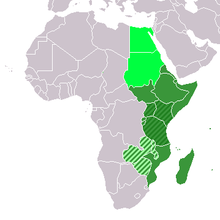
Green: Eastern Africa (UN Subregion)
Dark Green: East African Community
Very Light Green: Central African Federation (Political: Defunct)
Light Green: Geographic, including above