History of Ras Al Khaimah
However, the history of the land that the UAE occupies dates back to the Neolithic Age, which is evidenced by inscriptions, drawings and archaeological finds uncovered in the seven emirates during the period from the early 1950s to the present day.
Archaeologists have found evidence of human settlement in the Emirate of Ras Al Khaimah from 7,000 years ago, making it one of the oldest continuously inhabited places in the world.
There is a partly destroyed shell mound twenty-three kilometres south-west of the modern city of Ras Al Khaimah, near the abandoned fishing town of Jazirat al-Hamra.
[2] The site was first identified by German archaeologists in the late 1980s, when fragments of Mesopotamian pottery dating from the Ubaid period were found among the heap of fish bones and mollusc shells.
Their presence is evidence that the mound was of Neolithic origin and could be dated to the fifth or sixth millennia BC, indicating that the ceramic shards were some of the oldest pieces of pottery ever found in the lower Gulf.
[4] The climate conditions were friendlier 7,000 years ago, as there were freshwater lakes and grasslands for livestock, as well as extensive seagrass meadows that were suitable for dugong and other marine life.
[10] Khatt, a village renowned for its hot springs, is the oldest permanently inhabited area of Ras Al Khaimah, with evidence of human activity dating back to the Neolithic Period.
The majority of Wadi Suq sites are found along the northern coast, where human habitation was encouraged by maritime resources, palm gardens and availability of fresh water.
[17] The Iron Age (1300–600 BC) is defined by technological innovation, the development of mud brick villages, the appearance of notable fortifications, and the arrival of foreign powers and influence.
The Parthian Empire, which emerged in 247 BC, would become a major political and cultural power, but the exact extent of its influence in Ras Al Khaimah during the centuries leading up to the arrival of Islam is unclear.
According to the ninth century historian Ahmad Ibn Yahya al-Baladhuri, author of the Kitab Futuh al-Buldan (‘Book of the Conquests of Lands’), in the years prior to Islam, much of Oman and the eastern coast of the UAE was dominated by a branch of the Azd tribe known as the Banu Al Julanda.
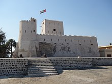
Julfar is the only settlement on the southern Arabian Gulf that is consistently mentioned by early Arab historians, due to its strategic location close the Strait of Hormuz, its safe harbour and access to the fertile palm gardens of Shimal.
Even the medieval geographer Al-Maqdisi mentions very little of the wider region, despite it being central to successive military campaigns, including those by the Abbasid caliphs during the ninth century.
[30] Julfar was the birthplace of the renowned navigator Ahmed ibn Majid, a focal point for maritime power, and the only port providing access from the Persian Gulf to south-east Arabia.
Although there is no accurate estimate of the size of the population, historians assume that it would have been substantial, with early Julfar linked to the coast by a lagoon and a network of navigable channels, despite now lying a few kilometres inland.
[37] At the turn of the sixteenth century, Ras Al Khaimah continued to be a major trading hub in south-east Arabia, with it being remaining strategically and logistically important.
[42] The Portuguese presence in Ras Al Khaimah lasted little over eleven years, and ended with the emergence of Nasir bin Murshid, the first Imam of the Ya’arabi dynasty of Oman.
They issued naval trade licenses, taxed passing vessels, and controlled commercial assets coming in and out of the Arabian Gulf, all of which put them in contact with the rulers of Ras Al Khaimah.
[46] The primary source of information relating to the emirate from this time comes from Baron Tiddo Frederik van Kniphausen, the Dutch East India Company’s agent on the island of Kharg.
Two British ships, the Trimmer and the Shannon, were attacked by Sheikh Qadhib al Qasimi, the ruler of Lingeh, in December of that year, followed by two confrontations with Qawasim vessels in 1805.
From the first expeditions of the English East India Company, to the country’s imperial heyday in the nineteenth century and its withdrawal from the Trucial States in 1971, Britain dominated the region.
Charles Rathbone Low, a British officer in the Indian Navy, says this in his 1870 book, The Land of the Sun: Sketches of Travel, with Memoranda, Historical and Geographical, of Places of Interest in the East: “According to Lieutenant Wellsted of the Indian Navy, the name of Jowassami was derived from Johasmi a Mohammedan saint, who first pitched his tent on the promontory where was built their chief port, called hence Ras-el-Khymah, or Cape Tent.”[53] The exact origins of the Qawasim are not known.
When German cartographer and explorer Carsten Niebuhr wrote about Ras Al Khaimah in the late eighteenth century, he referred to the ‘Schiech of Seer’ as being ‘of the tribe of Houle’.
The coast of Ras Al Khaimah was, and remains, a hub for maritime activity, from the traders of the Umm an-Nar era and ‘the ships of Magan’ to medieval Julfar and the fifteenth century navigator Ahmed bin Majid.
His Highness Sheikh Sultan bin Muhammad Al-Qasimi, Ruler of Sharjah, has carried out extensive research into the Qawasim, British accusations of piracy, and the power struggles that swept across the Arabian Gulf during the middle part of the eighteenth century.
His studies give a sense of the conflict that raged throughout that period: for example, in June 1760, the Qawasim arrived at Bandar Abbas with an estimated 800–1,000 men and a fleet of fifty vessels.
In 1761, a Qawasim fleet consisting of thirty gallivats (small armed boats), dhows and other vessels met a combined Omani and Banu Ma’in force, defeating them near the island of Larak.
Sheikh Sultan signed as the “Chief of the Joasmees”, with the treaty committing the signatories, as well as their heirs and successors, to “conclude together a lasting and inviolable peace from this time forth in perpetuity”.
The British had neglected the social and economic development of the Trucial States, which displease Sheikh Saqr, who sought to invest in Ras Al Khaimah’s agricultural potential.
[64] Ras Al Khaimah’s history, heritage and culture comes from its unique geographical features – mountains, coastal beaches, mangroves and the desert – along with its strategic location at the mouth of the Arabian Gulf.