History of the Yosemite area
[7] Displaced Native Americans from the Californian coast moved to the Sierra Nevada during the early-to-mid-19th century, bringing with them their knowledge of Spanish food, technology, and clothing.
[4] The first European Americans to visit the mountains were amongst a group led by fur trapper Jedediah Smith, crossing north of the Yosemite area in May 1827, at Ebbetts Pass.
[10] The part of the Sierra Nevada where the park is located was long considered to be a physical barrier to European American settlers, traders, trappers, and travelers.
[13] Joseph Screech returned two years later and spoke with the Native Americans living there, asking them what the name of a grass-covered seed meal was and was told, "hatch hatchy.
[16] James Savage's trading camp on the Merced River, 10 miles (16 km) west of Yosemite Valley,[11] was raided by Native Americans in December 1850, after which the raiders retreated into the mountains.
However by 1873, almost 80 percent of California's Native American population had been wiped out by conflict and disease, and their historic land seized by settlers from Mexico, South America, Europe, Australia, and China.
[17] In retaliation for the attack on his camp, a month later in January 1851, Jim Savage led a militia in a punitive action against a native village, but after opening fire they were beaten back by indigenous firepower.
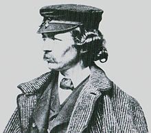
[27] Forty-eight Non-Indian people visited Yosemite Valley in 1855, including San Francisco writer James Mason Hutchings and artist Thomas Ayres.
[21] Hutchings published four installments of "The Great Yo-semite Valley" from October 1859 to March 1860 in his magazine and re-published a collection of these articles in his Scenes of Wonder and Curiosity in California, which remained in print into the 1870s.
[38] Oliver Wendell Holmes and John Greenleaf Whittier read and commented on Starr King's letters and landscape architect Frederick Law Olmsted was prompted by the warnings to visit the Yosemite area in 1863.
Josiah Whitney, the first director of the California Geological Survey, lamented that Yosemite Valley would meet the same fate as Niagara Falls, which at that time was a tourist trap with tolls on every bridge, path, trail, and viewpoint.
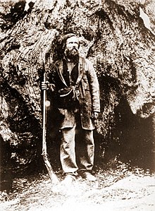
[55] Immediately following his arrival in California in March 1868, naturalist John Muir set out for the Yosemite area,[56] where he found work tending to the sheep owned by a local rancher, Pat Delaney.
[66] Galen Clark retired as the state grant's guardian in 1896, leaving Yosemite Valley and the Mariposa Grove of Big Trees under ineffective stewardship.
[69] To secure congressional and State of California approval for the plan, the size of the park was reduced by more than 500 square miles (1,300 km2),[70] which excluded natural wonders such as the Devils Postpile and prime wildlife habitat.
[71] About 12,000 acres (4,900 ha) between the Tuolumne and the Merced big tree groves were added to the park in 1930 through land purchases by the federal government and matching funds provided by industrialist John D.
Rights to Hetch Hetchy were granted to the City of San Francisco in 1908 by Secretary of the Interior James Rudolph Garfield, who wrote: "Domestic use is the highest use to which water and available storage basins ... can be put.
"[74] Pinchot, who was director of the U.S. Forest Service, wrote to his close friend Roosevelt that "the highest possible use which could be made of it would be to supply pure water to a great center of population.
[91][92] The Yosemite Firefall, in which the embers from a bonfire were pushed off a cliff near Glacier Point to create a spectacular effect, was ended in 1968 because it was deemed to be inconsistent with park values.
[94] Broader tensions in American society surfaced in Yosemite when a large number of youths gathered in the park over the summer of 1970, triggering a riot on July 4 after rangers tried to evict visitors from camping illegally in Stoneman Meadow.
After negotiating with Yosemite commissioners, they secured the rights to build and operate a toll road into the valley, enjoying a ten-year exclusivity period along the route.
[72] From the railway terminals in Stockton, Modesto, Copperopolis, Berenda, Merced, and Madera, seven routes competed to ferry tourists via stagecoach to Yosemite Valley.
[107] During the forty-year stagecoach era, Yosemite underwent significant changes, evolving into a national park and seeing the introduction of new hotels, public campgrounds, road improvements, and electricity.
[72] The decline of the stagecoach era began in the early 20th century with the introduction of the Yosemite Valley Railroad in 1907, which reduced the stage companies' traffic significantly.
[109]: 26, 66 It stretched from Merced to El Portal, the edge of Yosemite National Park, offering a safer, more comfortable option compared to the grueling two-day stagecoach trips common since the mid-1870s.
[110] Their journey was an attempt by Lippincott, a photography entrepreneur, to garner attention for a new store he intended to open in the valley, as well as to promote the Locomobile company.
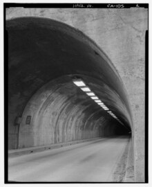
In 1933, construction began on a 35-mile stretch of Highway 41 between the Yosemite Valley and Mariposa Big Trees in preparation for the opening of the Wawona Tunnel, which cut through nearly a 1 mile (1.6 km) of solid granite.
The agency set an ambitious goal to eliminate all private vehicles from Yosemite Valley and Mariposa Grove to preserve the wilderness and natural beauty.
By the 20th century, fire suppression and the lowering of water tables by draining swamps led to the establishment of dense conifer forests where mixed and open conifer-oak woodlands had previously grown.
Muir wrote that even the "frivolous and inappreciative" visitors were on the whole "a most hopeful sign of the times, indicating at least the beginning of our return to nature – for going to the mountains is going home.
Current park managers focus on controlling nine high-priority invasive plant species of noxious weeds: yellow star-thistle (Centaurea solstitialis); spotted knapweed (Centaurea maculosa); Himalayan blackberry (Rubus armeniacus); bull thistle (Cirsium vulgare); velvet grass (Holcus lanatus); cheat grass (Bromus tectorum); French broom (Genista monspessulana); Italian thistle (Carduus pycnocephalus); and perennial pepperweed (Lepidium latifolium).